Mohawk elevation
Mohawk (New York, Herkimer County), United States elevation is 125 meters and Mohawk elevation in feet is 410 ft above sea level [src 1]. Mohawk is a populated place (feature code) with elevation that is 154 meters (505 ft) smaller than average city elevation in United States.
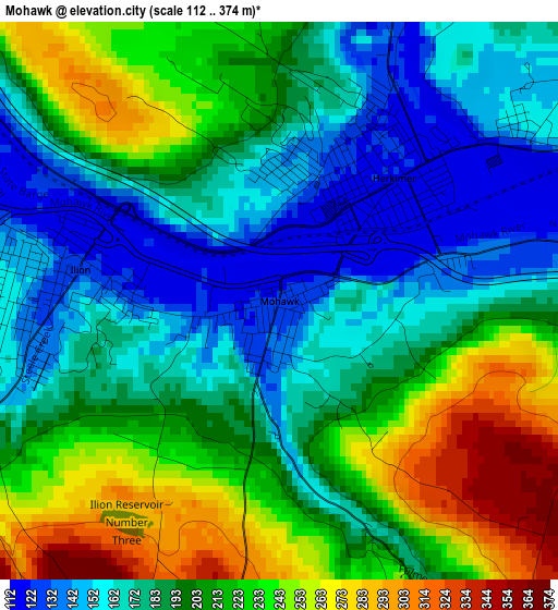
Below is the Elevation map of Mohawk, which displays elevation range with different colors. Scale of the first map is from 112 to 374 m (367 to 1227 ft) with average elevation of 198.6 meters (=652 ft) [note 1]
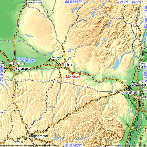
These maps also provides idea of topography and contour of this city, they are displayed at different zoom levels. More info about maps, scale and edge coordinates you can find below images.
| \ | Map #1 | Topo.Map |
| Scale [m] | 112..374 m | × |
| Scale [ft] | 367..1227 ft | × |
| Average | 198.6 m = 652 ft | × |
| Width | 7.15 km = 4.4 mi | 228.7 km = 142.1 mi |
| Height | 7.15 km = 4.4 mi | 228.7 km = 142.1 mi |
| ↑Max Latitude | 43.043585° | 44.03112° |
| Latitude at center | 43.01146° | 43.01146° |
| ↓Min Latitude | 42.979318° | 41.97459° |
| ← Min Longitude | -75.047985° | -76.41029° |
| Longitude center | -75.00404° | -75.00404° |
| →Max Longitude | -74.960095° | -73.59779° |
Nearby cities:
Cities around Mohawk sort by population:
• Utica elevation 143 m
21.1 km,  298°
298°
• Ilion 123 m
2.6 km,  278°
278°
• Herkimer 122 m
2.2 km,  42°
42°
• Little Falls 134 m
12.3 km,  73°
73°
• Yorkville 132 m
24.4 km, 297°
• Frankfort 126 m
6.2 km, 299°
• Dolgeville 245 m
21.2 km,  62°
62°
• New Hartford 163 m
24.1 km,  286°
286°
• Chadwicks 216 m
21.8 km,  274°
274°
• Springfield 417 m
23 km,  147°
147°
• Richfield Springs 402 m
17.6 km,  175°
175°
• Washington Mills 190 m
22.3 km, 281°
Multilingual:
 En español:
Mohawk elevación 125 m.
 En France:
Mohawk élévation 125 m.


Sources and notes:
- [note 1] Map square and city borders are not equal. Map elevation data is calculated only from area inside that square.
- [src 1] Elevation data from geonames database provided with same terms of usage.
- [src 2] The elevation map of Mohawk is generated using elevation data from NASA's 3 arcsec (90m) resolution SRTM data.
- [src 3] Base (background) map © OpenStreetMap contributors tiles are generated by Geofabrik and OpenTopoMap.
Copyright & License:
This Mohawk Elevation Map is licensed under CC BY-SA. You may reuse any part from this page, if you give a proper credit by linking to this URL:
 More info on terms of use page.