Little Falls elevation
Little Falls (New York, Herkimer County), United States elevation is 134 meters and Little Falls elevation in feet is 440 ft above sea level [src 1]. Little Falls is a populated place (feature code) with elevation that is 145 meters (476 ft) smaller than average city elevation in United States.
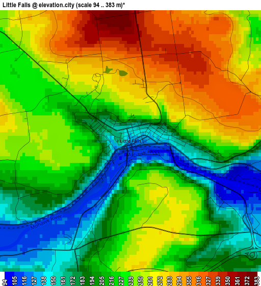
Below is the Elevation map of Little Falls, which displays elevation range with different colors. Scale of the first map is from 94 to 383 m (308 to 1257 ft) with average elevation of 231 meters (=758 ft) [note 1]
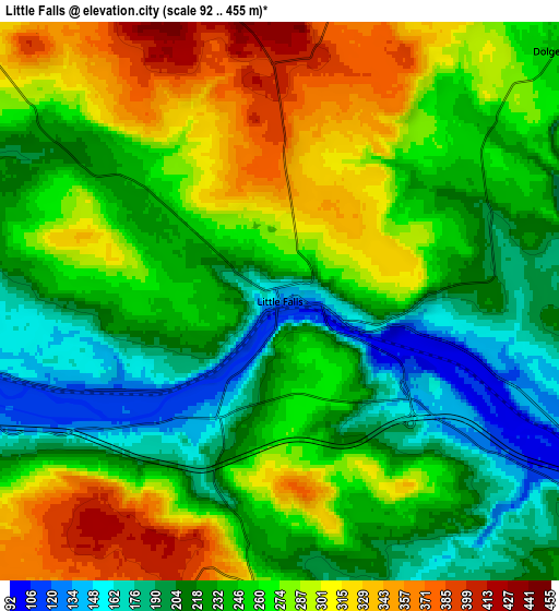
These maps also provides idea of topography and contour of this city, they are displayed at different zoom levels. More info about maps, scale and edge coordinates you can find below images.
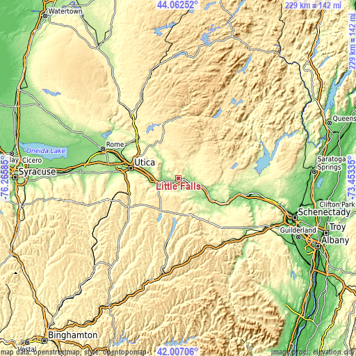
| \ | Map #1 | Map #2 | Topo.Map |
| Scale [m] | 94..383 m | 92..455 m | × |
| Scale [ft] | 308..1257 ft | 302..1493 ft | × |
| Average | 231 m = 758 ft | 252.9 m = 830 ft | × |
| Width | 7.14 km = 4.4 mi | 14.28 km = 8.9 mi | 228.5 km = 142 mi |
| Height | 7.14 km = 4.4 mi | 14.28 km = 8.9 mi | 228.5 km = 142 mi |
| ↑Max Latitude | 43.075508° | 43.1076° | 44.06252° |
| Latitude at center | 43.0434° | 43.0434° | 43.0434° |
| ↓Min Latitude | 43.011275° | 42.979133° | 42.00706° |
| ← Min Longitude | -74.903545° | -74.947491° | -76.26585° |
| Longitude center | -74.8596° | -74.8596° | -74.8596° |
| →Max Longitude | -74.815655° | -74.771709° | -73.45335° |
Nearby cities:
Cities around Little Falls sort by population:
• Utica elevation 143 m
31 km,  281°
281°
• Ilion 123 m
14.6 km,  257°
257°
• Herkimer 122 m
10.5 km, 259°
• Mohawk 125 m
12.3 km,  253°
253°
• Frankfort 126 m
17.1 km,  268°
268°
• Fort Plain 95 m
22.9 km,  122°
122°
• Canajoharie 96 m
28 km, 123°
• Dolgeville 245 m
9.5 km,  47°
47°
• Saint Johnsville 101 m
15.2 km,  109°
109°
• Chadwicks 216 m
33.5 km, 267°
• Springfield 417 m
23 km,  178°
178°
• Richfield Springs 402 m
23.5 km,  205°
205°
Multilingual:
 En español:
Little Falls elevación 134 m.
 En France:
Little Falls élévation 134 m.
 Auf Deutsch:
Little Falls höhe über dem Meeresspiegel ist 134 m.

Sources and notes:
- [note 1] Map square and city borders are not equal. Map elevation data is calculated only from area inside that square.
- [src 1] Elevation data from geonames database provided with same terms of usage.
- [src 2] The elevation map of Little Falls is generated using elevation data from NASA's 3 arcsec (90m) resolution SRTM data.
- [src 3] Base (background) map © OpenStreetMap contributors tiles are generated by Geofabrik and OpenTopoMap.
Copyright & License:
This Little Falls Elevation Map is licensed under CC BY-SA. You may reuse any part from this page, if you give a proper credit by linking to this URL:
 More info on terms of use page.