Mahopac elevation
Mahopac (New York, Putnam County), United States elevation is 212 meters and Mahopac elevation in feet is 696 ft above sea level [src 1]. Mahopac is a populated place (feature code) with elevation that is 67 meters (220 ft) smaller than average city elevation in United States.
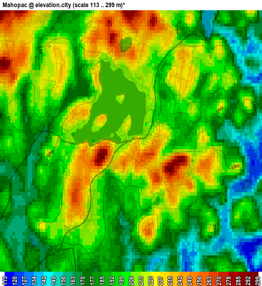
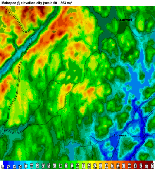
Below is the Elevation map of Mahopac, which displays elevation range with different colors. Scale of the first map is from 113 to 299 m (371 to 981 ft) with average elevation of 198.8 meters (=652 ft) [note 1]
These maps also provides idea of topography and contour of this city, they are displayed at different zoom levels. More info about maps, scale and edge coordinates you can find below images.
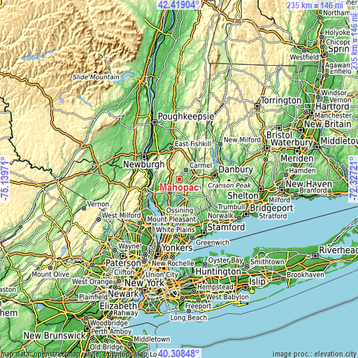
| \ | Map #1 | Map #2 | Topo.Map |
| Scale [m] | 113..299 m | 60..363 m | × |
| Scale [ft] | 371..981 ft | 197..1191 ft | × |
| Average | 198.8 m = 652 ft | 182.5 m = 599 ft | × |
| Width | 7.33 km = 4.6 mi | 14.67 km = 9.1 mi | 234.7 km = 145.8 mi |
| Height | 7.33 km = 4.6 mi | 14.67 km = 9.1 mi | 234.7 km = 145.8 mi |
| ↑Max Latitude | 41.40529° | 41.438242° | 42.41904° |
| Latitude at center | 41.37232° | 41.37232° | 41.37232° |
| ↓Min Latitude | 41.339334° | 41.306331° | 40.30848° |
| ← Min Longitude | -73.777405° | -73.821351° | -75.13971° |
| Longitude center | -73.73346° | -73.73346° | -73.73346° |
| →Max Longitude | -73.689515° | -73.645569° | -72.32721° |
Nearby cities:
Cities around Mahopac sort by population:
• Jefferson Valley-Yorktown elevation 202 m
8.2 km,  222°
222°
• Lake Carmel 243 m
11.2 km,  27°
27°
• Carmel Hamlet 159 m
6.2 km,  40°
40°
• Lake Mohegan 161 m
11.2 km,  237°
237°
• Carmel 175 m
7.8 km, 34°
• Heritage Hills 201 m
4.7 km,  140°
140°
• Brewster 150 m
10.1 km,  74°
74°
• Shrub Oak 144 m
8.7 km, 235°
• Shenorock 160 m
4.5 km,  185°
185°
• Yorktown Heights 155 m
11.9 km,  198°
198°
• Goldens Bridge 72 m
10 km,  151°
151°
• Lincolndale 116 m
5.6 km,  166°
166°
Multilingual:
 En español:
Mahopac elevación 212 m.
 En France:
Mahopac élévation 212 m.


Sources and notes:
- [note 1] Map square and city borders are not equal. Map elevation data is calculated only from area inside that square.
- [src 1] Elevation data from geonames database provided with same terms of usage.
- [src 2] The elevation map of Mahopac is generated using elevation data from NASA's 3 arcsec (90m) resolution SRTM data.
- [src 3] Base (background) map © OpenStreetMap contributors tiles are generated by Geofabrik and OpenTopoMap.
Copyright & License:
This Mahopac Elevation Map is licensed under CC BY-SA. You may reuse any part from this page, if you give a proper credit by linking to this URL:
 More info on terms of use page.