Lattingtown elevation
Lattingtown (New York, Nassau County), United States elevation is 27 meters and Lattingtown elevation in feet is 89 ft above sea level [src 1]. Lattingtown is a populated place (feature code) with elevation that is 252 meters (827 ft) smaller than average city elevation in United States.
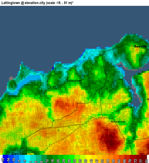
Below is the Elevation map of Lattingtown, which displays elevation range with different colors. Scale of the first map is from -18 to 81 m (-59 to 266 ft) with average elevation of 32.2 meters (=106 ft) [note 1]
These maps also provides idea of topography and contour of this city, they are displayed at different zoom levels. More info about maps, scale and edge coordinates you can find below images.
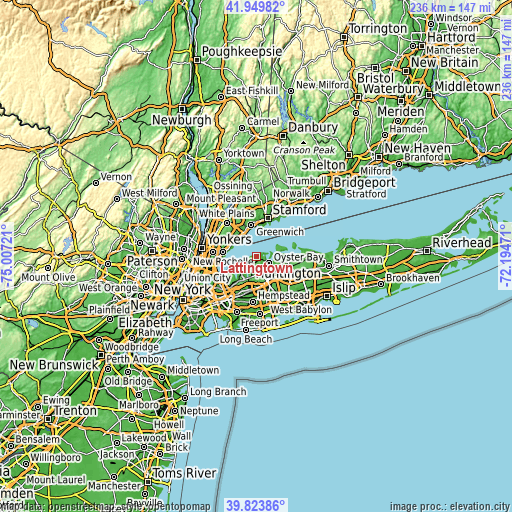
| \ | Map #1 | Topo.Map |
| Scale [m] | -18..81 m | × |
| Scale [ft] | -59..266 ft | × |
| Average | 32.2 m = 106 ft | × |
| Width | 7.39 km = 4.6 mi | 236.4 km = 146.9 mi |
| Height | 7.39 km = 4.6 mi | 236.4 km = 146.9 mi |
| ↑Max Latitude | 40.92859° | 41.94982° |
| Latitude at center | 40.89538° | 40.89538° |
| ↓Min Latitude | 40.862153° | 39.82386° |
| ← Min Longitude | -73.644905° | -75.00721° |
| Longitude center | -73.60096° | -73.60096° |
| →Max Longitude | -73.557015° | -72.19471° |
Nearby cities:
Cities around Lattingtown sort by population:
• Glen Cove elevation 9 m
4.6 km,  216°
216°
• Bayville 17 m
3.7 km,  62°
62°
• Oyster Bay 14 m
6.7 km,  119°
119°
• Sea Cliff 58 m
6.3 km, 215°
• Glen Head 35 m
6.9 km,  196°
196°
• Glenwood Landing 36 m
7.9 km, 203°
• Locust Valley 40 m
2.2 km,  171°
171°
• East Norwich 65 m
7.7 km,  134°
134°
• Oyster Bay Cove 26 m
8 km,  109°
109°
• Old Brookville 35 m
7.1 km,  182°
182°
• Upper Brookville 58 m
7 km,  154°
154°
• Mill Neck 45 m
4 km,  103°
103°
Multilingual:
 En español:
Lattingtown elevación 27 m.
 En France:
Lattingtown élévation 27 m.
 Auf Deutsch:
Lattingtown höhe über dem Meeresspiegel ist 27 m.

Sources and notes:
- [note 1] Map square and city borders are not equal. Map elevation data is calculated only from area inside that square.
- [src 1] Elevation data from geonames database provided with same terms of usage.
- [src 2] The elevation map of Lattingtown is generated using elevation data from NASA's 3 arcsec (90m) resolution SRTM data.
- [src 3] Base (background) map © OpenStreetMap contributors tiles are generated by Geofabrik and OpenTopoMap.
Copyright & License:
This Lattingtown Elevation Map is licensed under CC BY-SA. You may reuse any part from this page, if you give a proper credit by linking to this URL:
 More info on terms of use page.