Lake Pleasant elevation
Lake Pleasant (New York, Hamilton County), United States elevation is 546 meters and Lake Pleasant elevation in feet is 1791 ft above sea level [src 1]. Lake Pleasant is a seat of a second-order administrative division (feature code) with elevation that is 267 meters (876 ft) bigger than average city elevation in United States.
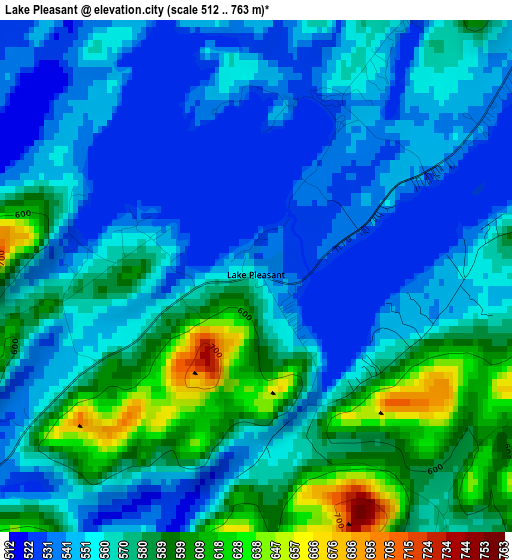
Below is the Elevation map of Lake Pleasant, which displays elevation range with different colors. Scale of the first map is from 512 to 763 m (1680 to 2503 ft) with average elevation of 564 meters (=1850 ft) [note 1]
These maps also provides idea of topography and contour of this city, they are displayed at different zoom levels. More info about maps, scale and edge coordinates you can find below images.
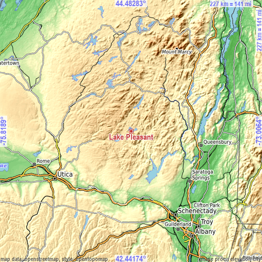
| \ | Map #1 | Topo.Map |
| Scale [m] | 512..763 m | × |
| Scale [ft] | 1680..2503 ft | × |
| Average | 564 m = 1850 ft | × |
| Width | 7.09 km = 4.4 mi | 226.9 km = 141 mi |
| Height | 7.09 km = 4.4 mi | 226.9 km = 141 mi |
| ↑Max Latitude | 43.502784° | 44.48283° |
| Latitude at center | 43.4709° | 43.4709° |
| ↓Min Latitude | 43.438999° | 42.44174° |
| ← Min Longitude | -74.456595° | -75.8189° |
| Longitude center | -74.41265° | -74.41265° |
| →Max Longitude | -74.368705° | -73.0064° |
Nearby cities:
Cities around Lake Pleasant sort by population:
• Gloversville elevation 256 m
46.8 km,  173°
173°
• Johnstown 208 m
51.7 km,  175°
175°
• Perth 268 m
53.4 km,  160°
160°
• Warrensburg 230 m
51.4 km,  86°
86°
• Corinth 186 m
53.2 km,  118°
118°
• Dolgeville 245 m
50.4 km,  215°
215°
• Saint Johnsville 101 m
56.9 km,  202°
202°
• Broadalbin 249 m
49.1 km, 159°
• Lake Luzerne 171 m
49.9 km,  110°
110°
• Edinburg 276 m
37.3 km,  137°
137°
• Northville 248 m
33.5 km, 144°
• Hadley 193 m
48.7 km, 110°
Multilingual:
 En español:
Lake Pleasant elevación 546 m.
 En France:
Lake Pleasant élévation 546 m.
 Auf Deutsch:
Lake Pleasant höhe über dem Meeresspiegel ist 546 m.

Sources and notes:
- [note 1] Map square and city borders are not equal. Map elevation data is calculated only from area inside that square.
- [src 1] Elevation data from geonames database provided with same terms of usage.
- [src 2] The elevation map of Lake Pleasant is generated using elevation data from NASA's 3 arcsec (90m) resolution SRTM data.
- [src 3] Base (background) map © OpenStreetMap contributors tiles are generated by Geofabrik and OpenTopoMap.
Copyright & License:
This Lake Pleasant Elevation Map is licensed under CC BY-SA. You may reuse any part from this page, if you give a proper credit by linking to this URL:
 More info on terms of use page.