Gloversville elevation
Gloversville (New York, Fulton County), United States elevation is 256 meters and Gloversville elevation in feet is 840 ft above sea level [src 1]. Gloversville is a populated place (feature code) with elevation that is 23 meters (75 ft) smaller than average city elevation in United States.
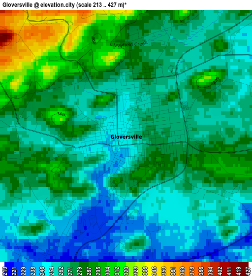
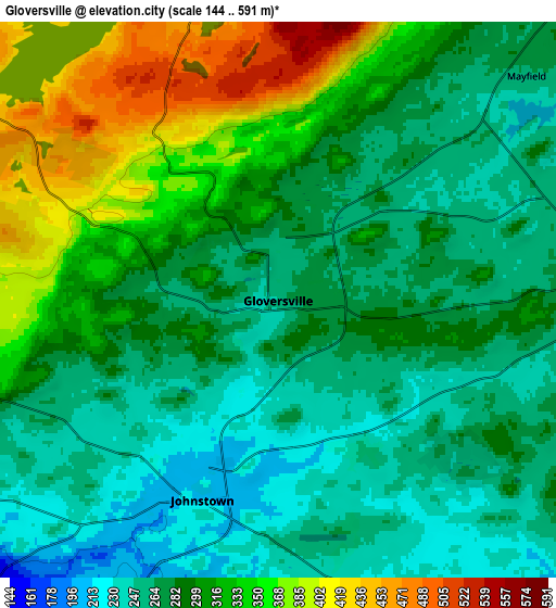
Below is the Elevation map of Gloversville, which displays elevation range with different colors. Scale of the first map is from 213 to 427 m (699 to 1401 ft) with average elevation of 271.3 meters (=890 ft) [note 1]
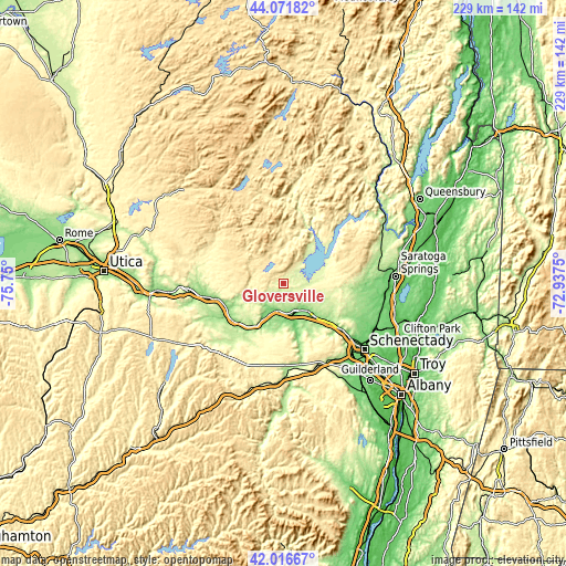
These maps also provides idea of topography and contour of this city, they are displayed at different zoom levels. More info about maps, scale and edge coordinates you can find below images.
| \ | Map #1 | Map #2 | Topo.Map |
| Scale [m] | 213..427 m | 144..591 m | × |
| Scale [ft] | 699..1401 ft | 472..1939 ft | × |
| Average | 271.3 m = 890 ft | 297.1 m = 975 ft | × |
| Width | 7.14 km = 4.4 mi | 14.28 km = 8.9 mi | 228.5 km = 142 mi |
| Height | 7.14 km = 4.4 mi | 14.28 km = 8.9 mi | 228.5 km = 142 mi |
| ↑Max Latitude | 43.084954° | 43.11704° | 44.07182° |
| Latitude at center | 43.05285° | 43.05285° | 43.05285° |
| ↓Min Latitude | 43.02073° | 42.988593° | 42.01667° |
| ← Min Longitude | -74.387695° | -74.431641° | -75.75° |
| Longitude center | -74.34375° | -74.34375° | -74.34375° |
| →Max Longitude | -74.299805° | -74.255859° | -72.9375° |
Nearby cities:
Cities around Gloversville sort by population:
• Amsterdam elevation 110 m
17.9 km,  135°
135°
• Johnstown 208 m
5.5 km,  200°
200°
• Wellsville 118 m
20.5 km,  163°
163°
• Perth 268 m
12.8 km,  107°
107°
• Fort Plain 95 m
26.4 km,  239°
239°
• Canajoharie 96 m
24.7 km,  228°
228°
• Broadalbin 249 m
12 km,  86°
86°
• Hagaman 221 m
17.9 km,  119°
119°
• Edinburg 276 m
27 km,  46°
46°
• Northville 248 m
23.7 km,  35°
35°
• Tribes Hill 130 m
11.8 km, 156°
• Fonda 90 m
11.3 km,  193°
193°
Multilingual:
 En español:
Gloversville elevación 256 m.
 En France:
Gloversville élévation 256 m.
 Auf Deutsch:
Gloversville höhe über dem Meeresspiegel ist 256 m.

Sources and notes:
- [note 1] Map square and city borders are not equal. Map elevation data is calculated only from area inside that square.
- [src 1] Elevation data from geonames database provided with same terms of usage.
- [src 2] The elevation map of Gloversville is generated using elevation data from NASA's 3 arcsec (90m) resolution SRTM data.
- [src 3] Base (background) map © OpenStreetMap contributors tiles are generated by Geofabrik and OpenTopoMap.
Copyright & License:
This Gloversville Elevation Map is licensed under CC BY-SA. You may reuse any part from this page, if you give a proper credit by linking to this URL:
 More info on terms of use page.