Canastota elevation
Canastota (New York, Madison County), United States elevation is 131 meters and Canastota elevation in feet is 430 ft above sea level [src 1]. Canastota is a populated place (feature code) with elevation that is 148 meters (486 ft) smaller than average city elevation in United States.
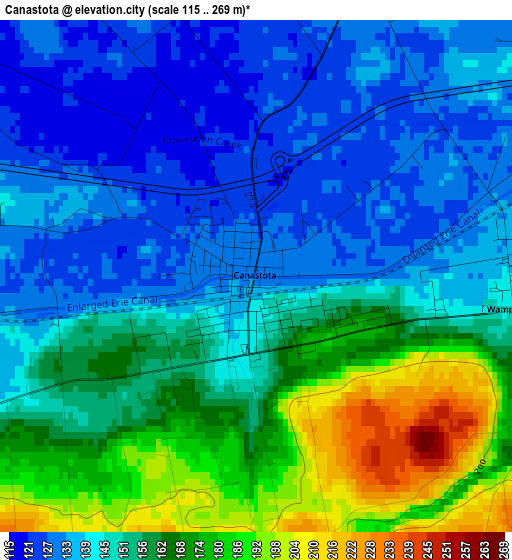
Below is the Elevation map of Canastota, which displays elevation range with different colors. Scale of the first map is from 115 to 269 m (377 to 883 ft) with average elevation of 151.8 meters (=498 ft) [note 1]
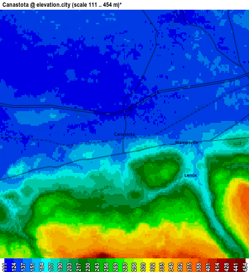
These maps also provides idea of topography and contour of this city, they are displayed at different zoom levels. More info about maps, scale and edge coordinates you can find below images.
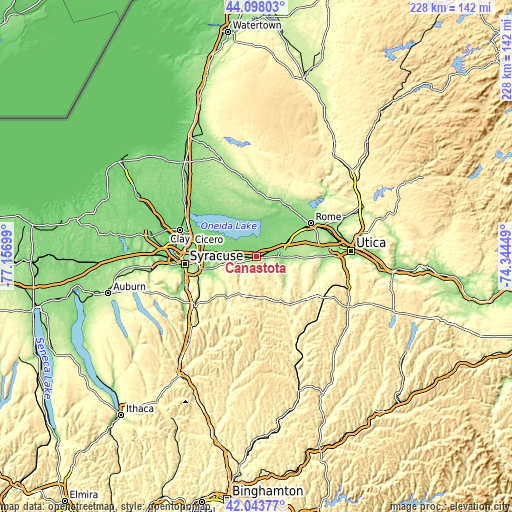
| \ | Map #1 | Map #2 | Topo.Map |
| Scale [m] | 115..269 m | 111..454 m | × |
| Scale [ft] | 377..883 ft | 364..1490 ft | × |
| Average | 151.8 m = 498 ft | 179.9 m = 590 ft | × |
| Width | 7.14 km = 4.4 mi | 14.28 km = 8.9 mi | 228.4 km = 141.9 mi |
| Height | 7.14 km = 4.4 mi | 14.28 km = 8.9 mi | 228.4 km = 141.9 mi |
| ↑Max Latitude | 43.1116° | 43.143672° | 44.09803° |
| Latitude at center | 43.07951° | 43.07951° | 43.07951° |
| ↓Min Latitude | 43.047404° | 43.01528° | 42.04377° |
| ← Min Longitude | -75.794685° | -75.838631° | -77.15699° |
| Longitude center | -75.75074° | -75.75074° | -75.75074° |
| →Max Longitude | -75.706795° | -75.662849° | -74.34449° |
Nearby cities:
Cities around Canastota sort by population:
• Oneida elevation 134 m
8.2 km,  79°
79°
• Chittenango 139 m
10.2 km,  247°
247°
• Manlius 181 m
20.3 km,  244°
244°
• Fayetteville 161 m
21.3 km, 254°
• Minoa 128 m
20.3 km,  268°
268°
• Sherrill 151 m
12.4 km,  92°
92°
• Cazenovia 374 m
18.6 km,  206°
206°
• Morrisville 407 m
22 km,  155°
155°
• Bridgeport 122 m
19.6 km,  295°
295°
• Vernon 194 m
17.2 km, 90°
• Bolivar 131 m
11.3 km, 265°
• Wampsville 147 m
3.6 km,  97°
97°
Multilingual:
 En español:
Canastota elevación 131 m.
 En France:
Canastota élévation 131 m.
 Auf Deutsch:
Canastota höhe über dem Meeresspiegel ist 131 m.

Sources and notes:
- [note 1] Map square and city borders are not equal. Map elevation data is calculated only from area inside that square.
- [src 1] Elevation data from geonames database provided with same terms of usage.
- [src 2] The elevation map of Canastota is generated using elevation data from NASA's 3 arcsec (90m) resolution SRTM data.
- [src 3] Base (background) map © OpenStreetMap contributors tiles are generated by Geofabrik and OpenTopoMap.
Copyright & License:
This Canastota Elevation Map is licensed under CC BY-SA. You may reuse any part from this page, if you give a proper credit by linking to this URL:
 More info on terms of use page.