Fayetteville elevation
Fayetteville (New York, Onondaga County), United States elevation is 161 meters and Fayetteville elevation in feet is 528 ft above sea level [src 1]. Fayetteville is a populated place (feature code) with elevation that is 118 meters (387 ft) smaller than average city elevation in United States.
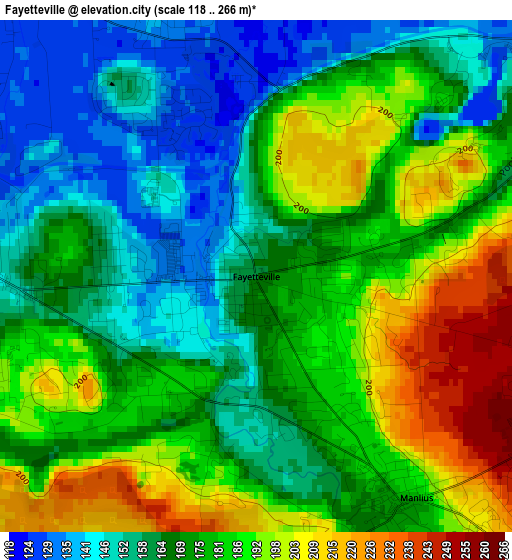
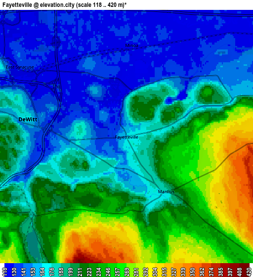
Below is the Elevation map of Fayetteville, which displays elevation range with different colors. Scale of the first map is from 118 to 266 m (387 to 873 ft) with average elevation of 174.8 meters (=573 ft) [note 1]
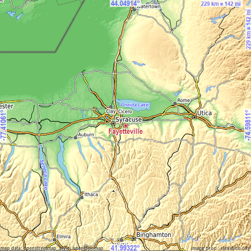
These maps also provides idea of topography and contour of this city, they are displayed at different zoom levels. More info about maps, scale and edge coordinates you can find below images.
| \ | Map #1 | Map #2 | Topo.Map |
| Scale [m] | 118..266 m | 118..420 m | × |
| Scale [ft] | 387..873 ft | 387..1378 ft | × |
| Average | 174.8 m = 573 ft | 195.4 m = 641 ft | × |
| Width | 7.14 km = 4.4 mi | 14.29 km = 8.9 mi | 228.6 km = 142 mi |
| Height | 7.14 km = 4.4 mi | 14.29 km = 8.9 mi | 228.6 km = 142 mi |
| ↑Max Latitude | 43.061906° | 43.094004° | 44.04914° |
| Latitude at center | 43.02979° | 43.02979° | 43.02979° |
| ↓Min Latitude | 42.997658° | 42.965508° | 41.99322° |
| ← Min Longitude | -76.048305° | -76.092251° | -77.41061° |
| Longitude center | -76.00436° | -76.00436° | -76.00436° |
| →Max Longitude | -75.960415° | -75.916469° | -74.59811° |
Nearby cities:
Cities around Fayetteville sort by population:
• Syracuse elevation 129 m
11.8 km,  279°
279°
• North Syracuse 128 m
15.5 km,  318°
318°
• Mattydale 122 m
13.7 km,  303°
303°
• Chittenango 139 m
11.3 km,  81°
81°
• Manlius 181 m
3.8 km,  144°
144°
• Galeville 131 m
15.3 km, 296°
• Lyncourt 134 m
11.4 km, 300°
• Minoa 128 m
5.2 km,  3°
3°
• East Syracuse 136 m
7.2 km, 303°
• Nedrow 147 m
12.7 km,  241°
241°
• Bridgeport 122 m
14.2 km,  11°
11°
• Bolivar 131 m
10.5 km,  63°
63°
Multilingual:
 En español:
Fayetteville elevación 161 m.
 En France:
Fayetteville élévation 161 m.
 Auf Deutsch:
Fayetteville höhe über dem Meeresspiegel ist 161 m.

Sources and notes:
- [note 1] Map square and city borders are not equal. Map elevation data is calculated only from area inside that square.
- [src 1] Elevation data from geonames database provided with same terms of usage.
- [src 2] The elevation map of Fayetteville is generated using elevation data from NASA's 3 arcsec (90m) resolution SRTM data.
- [src 3] Base (background) map © OpenStreetMap contributors tiles are generated by Geofabrik and OpenTopoMap.
Copyright & License:
This Fayetteville Elevation Map is licensed under CC BY-SA. You may reuse any part from this page, if you give a proper credit by linking to this URL:
 More info on terms of use page.