Buchanan elevation
Buchanan (New York, Westchester County), United States elevation is 19 meters and Buchanan elevation in feet is 62 ft above sea level [src 1]. Buchanan is a populated place (feature code) with elevation that is 260 meters (853 ft) smaller than average city elevation in United States.
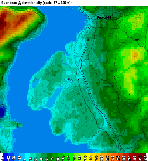
Below is the Elevation map of Buchanan, which displays elevation range with different colors. Scale of the first map is from -57 to 325 m (-187 to 1066 ft) with average elevation of 50.6 meters (=166 ft) [note 1]
These maps also provides idea of topography and contour of this city, they are displayed at different zoom levels. More info about maps, scale and edge coordinates you can find below images.
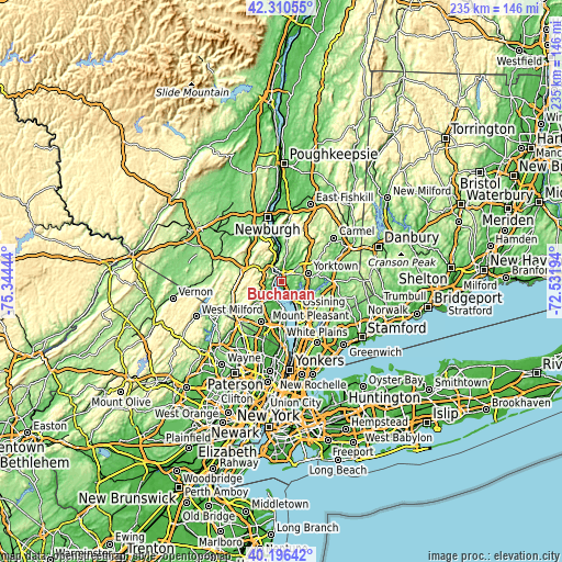
| \ | Map #1 | Topo.Map |
| Scale [m] | -57..325 m | × |
| Scale [ft] | -187..1066 ft | × |
| Average | 50.6 m = 166 ft | × |
| Width | 7.35 km = 4.6 mi | 235.1 km = 146.1 mi |
| Height | 7.35 km = 4.6 mi | 235.1 km = 146.1 mi |
| ↑Max Latitude | 41.295065° | 42.31055° |
| Latitude at center | 41.26204° | 41.26204° |
| ↓Min Latitude | 41.228998° | 40.19642° |
| ← Min Longitude | -73.982135° | -75.34444° |
| Longitude center | -73.93819° | -73.93819° |
| →Max Longitude | -73.894245° | -72.53194° |
Nearby cities:
Cities around Buchanan sort by population:
• Peekskill elevation 49 m
3.5 km,  25°
25°
• Haverstraw 13 m
7.5 km,  197°
197°
• Stony Point 35 m
5.5 km,  228°
228°
• West Haverstraw 39 m
7 km,  214°
214°
• Croton-on-Hudson 52 m
7.1 km,  146°
146°
• Lake Mohegan 161 m
9.9 km,  51°
51°
• Thiells 90 m
8.8 km, 229°
• Montrose 37 m
1.2 km, 152°
• Crompond 131 m
7.1 km,  58°
58°
• Verplanck 22 m
2.1 km,  240°
240°
• Fort Montgomery 55 m
8.7 km,  332°
332°
• Crugers 32 m
3.4 km,  157°
157°
Multilingual:
 En español:
Buchanan elevación 19 m.
 En France:
Buchanan élévation 19 m.


Sources and notes:
- [note 1] Map square and city borders are not equal. Map elevation data is calculated only from area inside that square.
- [src 1] Elevation data from geonames database provided with same terms of usage.
- [src 2] The elevation map of Buchanan is generated using elevation data from NASA's 3 arcsec (90m) resolution SRTM data.
- [src 3] Base (background) map © OpenStreetMap contributors tiles are generated by Geofabrik and OpenTopoMap.
Copyright & License:
This Buchanan Elevation Map is licensed under CC BY-SA. You may reuse any part from this page, if you give a proper credit by linking to this URL:
 More info on terms of use page.