Bath elevation
Bath (New York, Steuben County), United States elevation is 340 meters and Bath elevation in feet is 1115 ft above sea level [src 1]. Bath is a seat of a second-order administrative division (feature code) with elevation that is 61 meters (200 ft) bigger than average city elevation in United States.
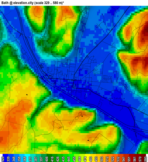
Below is the Elevation map of Bath, which displays elevation range with different colors. Scale of the first map is from 329 to 580 m (1079 to 1903 ft) with average elevation of 411.6 meters (=1350 ft) [note 1]
These maps also provides idea of topography and contour of this city, they are displayed at different zoom levels. More info about maps, scale and edge coordinates you can find below images.
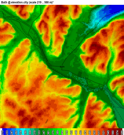
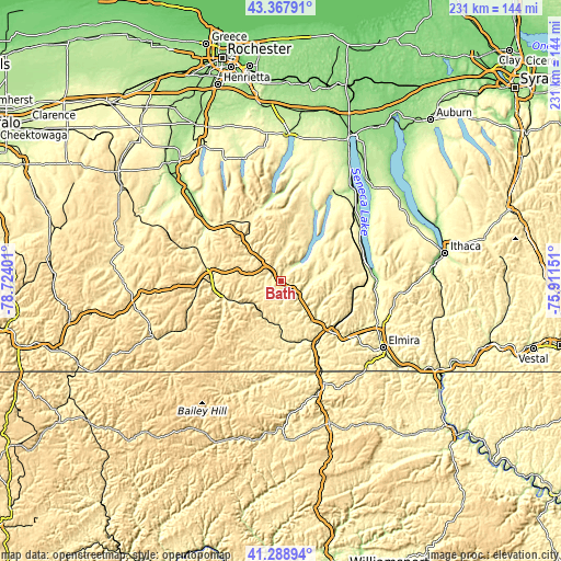
| \ | Map #1 | Map #2 | Topo.Map |
| Scale [m] | 329..580 m | 219..588 m | × |
| Scale [ft] | 1079..1903 ft | 719..1929 ft | × |
| Average | 411.6 m = 1350 ft | 435.5 m = 1429 ft | × |
| Width | 7.22 km = 4.5 mi | 14.45 km = 9 mi | 231.2 km = 143.7 mi |
| Height | 7.22 km = 4.5 mi | 14.45 km = 9 mi | 231.2 km = 143.7 mi |
| ↑Max Latitude | 42.369496° | 42.401955° | 43.36791° |
| Latitude at center | 42.33702° | 42.33702° | 42.33702° |
| ↓Min Latitude | 42.304527° | 42.272018° | 41.28894° |
| ← Min Longitude | -77.361705° | -77.405651° | -78.72401° |
| Longitude center | -77.31776° | -77.31776° | -77.31776° |
| →Max Longitude | -77.273815° | -77.229869° | -75.91151° |
Nearby cities:
Cities around Bath sort by population:
• Corning elevation 289 m
30.6 km,  134°
134°
• Hornell 356 m
28.2 km,  267°
267°
• Gang Mills 290 m
27.2 km,  141°
141°
• Canisteo 348 m
24.8 km,  252°
252°
• Painted Post 291 m
26.8 km, 136°
• Wayland 418 m
34 km,  318°
318°
• Addison 304 m
26.9 km,  165°
165°
• Dundee 302 m
34.8 km,  53°
53°
• Keuka Park 239 m
36.1 km,  30°
30°
• South Corning 293 m
33.3 km, 136°
• Sylvan Beach 345 m
22.3 km, 50°
• Naples 246 m
31.7 km,  347°
347°
Multilingual:
 En español:
Bath elevación 340 m.
 En France:
Bath élévation 340 m.


Sources and notes:
- [note 1] Map square and city borders are not equal. Map elevation data is calculated only from area inside that square.
- [src 1] Elevation data from geonames database provided with same terms of usage.
- [src 2] The elevation map of Bath is generated using elevation data from NASA's 3 arcsec (90m) resolution SRTM data.
- [src 3] Base (background) map © OpenStreetMap contributors tiles are generated by Geofabrik and OpenTopoMap.
Copyright & License:
This Bath Elevation Map is licensed under CC BY-SA. You may reuse any part from this page, if you give a proper credit by linking to this URL:
 More info on terms of use page.