Eagle elevation
Eagle (Nebraska, Cass County), United States elevation is 415 meters and Eagle elevation in feet is 1362 ft above sea level [src 1]. Eagle is a populated place (feature code) with elevation that is 136 meters (446 ft) bigger than average city elevation in United States.
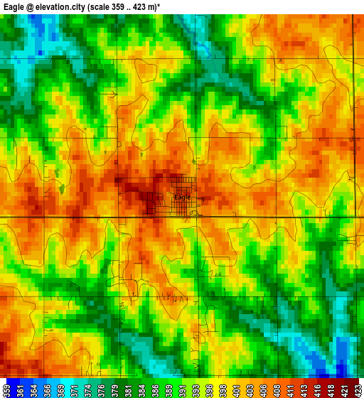
Below is the Elevation map of Eagle, which displays elevation range with different colors. Scale of the first map is from 359 to 423 m (1178 to 1388 ft) with average elevation of 393.9 meters (=1292 ft) [note 1]
These maps also provides idea of topography and contour of this city, they are displayed at different zoom levels. More info about maps, scale and edge coordinates you can find below images.
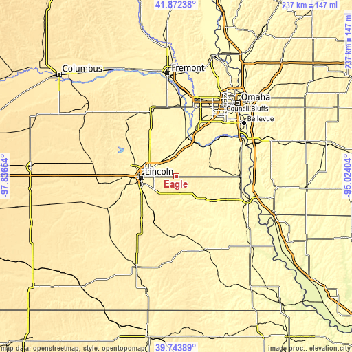
| \ | Map #1 | Topo.Map |
| Scale [m] | 359..423 m | × |
| Scale [ft] | 1178..1388 ft | × |
| Average | 393.9 m = 1292 ft | × |
| Width | 7.4 km = 4.6 mi | 236.7 km = 147.1 mi |
| Height | 7.4 km = 4.6 mi | 236.7 km = 147.1 mi |
| ↑Max Latitude | 40.84992° | 41.87238° |
| Latitude at center | 40.81667° | 40.81667° |
| ↓Min Latitude | 40.783404° | 39.74389° |
| ← Min Longitude | -96.474235° | -97.83654° |
| Longitude center | -96.43029° | -96.43029° |
| →Max Longitude | -96.386345° | -95.02404° |
Nearby cities:
Cities around Eagle sort by population:
• Lincoln elevation 366 m
20 km,  264°
264°
• Chalco 329 m
47.1 km,  29°
29°
• Gretna 390 m
39.4 km,  23°
23°
• Wahoo 371 m
46.7 km,  340°
340°
• Waverly 347 m
13.9 km,  323°
323°
• Ashland 332 m
25.3 km,  11°
11°
• Hickman 391 m
27.6 km,  217°
217°
• Syracuse 320 m
27.1 km,  130°
130°
• Springfield 330 m
38.6 km,  40°
40°
• Yutan 358 m
47.7 km,  3°
3°
• Louisville 325 m
30.2 km,  48°
48°
• Weeping Water 337 m
25.1 km,  76°
76°
Multilingual:
 En español:
Eagle elevación 415 m.
 En France:
Eagle élévation 415 m.


Sources and notes:
- [note 1] Map square and city borders are not equal. Map elevation data is calculated only from area inside that square.
- [src 1] Elevation data from geonames database provided with same terms of usage.
- [src 2] The elevation map of Eagle is generated using elevation data from NASA's 3 arcsec (90m) resolution SRTM data.
- [src 3] Base (background) map © OpenStreetMap contributors tiles are generated by Geofabrik and OpenTopoMap.
Copyright & License:
This Eagle Elevation Map is licensed under CC BY-SA. You may reuse any part from this page, if you give a proper credit by linking to this URL:
 More info on terms of use page.