Albion elevation
Albion (Nebraska, Boone County), United States elevation is 544 meters and Albion elevation in feet is 1785 ft above sea level [src 1]. Albion is a seat of a second-order administrative division (feature code) with elevation that is 265 meters (869 ft) bigger than average city elevation in United States.
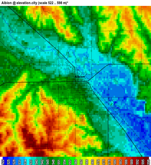
Below is the Elevation map of Albion, which displays elevation range with different colors. Scale of the first map is from 522 to 598 m (1713 to 1962 ft) with average elevation of 552.7 meters (=1813 ft) [note 1]
These maps also provides idea of topography and contour of this city, they are displayed at different zoom levels. More info about maps, scale and edge coordinates you can find below images.
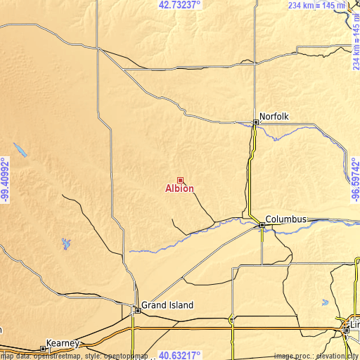
| \ | Map #1 | Topo.Map |
| Scale [m] | 522..598 m | × |
| Scale [ft] | 1713..1962 ft | × |
| Average | 552.7 m = 1813 ft | × |
| Width | 7.3 km = 4.5 mi | 233.5 km = 145.1 mi |
| Height | 7.3 km = 4.5 mi | 233.5 km = 145.1 mi |
| ↑Max Latitude | 41.723648° | 42.73237° |
| Latitude at center | 41.69084° | 41.69084° |
| ↓Min Latitude | 41.658016° | 40.63217° |
| ← Min Longitude | -98.047615° | -99.40992° |
| Longitude center | -98.00367° | -98.00367° |
| →Max Longitude | -97.959725° | -96.59742° |
Nearby cities:
Cities around Albion sort by population:
• Norfolk elevation 463 m
61.4 km,  52°
52°
• Columbus 442 m
60.3 km,  118°
118°
• Central City 519 m
63.9 km,  179°
179°
• Madison 483 m
48 km,  71°
71°
• Saint Paul 555 m
65.1 km,  215°
215°
• Pierce 484 m
68.9 km,  34°
34°
• Neligh 537 m
48.7 km,  357°
357°
• Fullerton 504 m
36.5 km, 175°
• Battle Creek 486 m
48 km,  44°
44°
• Osceola 510 m
68.4 km,  146°
146°
• Greeley 618 m
46.6 km,  250°
250°
• Bartlett 669 m
50.4 km,  295°
295°
Multilingual:
 En español:
Albion elevación 544 m.
 En France:
Albion élévation 544 m.


Sources and notes:
- [note 1] Map square and city borders are not equal. Map elevation data is calculated only from area inside that square.
- [src 1] Elevation data from geonames database provided with same terms of usage.
- [src 2] The elevation map of Albion is generated using elevation data from NASA's 3 arcsec (90m) resolution SRTM data.
- [src 3] Base (background) map © OpenStreetMap contributors tiles are generated by Geofabrik and OpenTopoMap.
Copyright & License:
This Albion Elevation Map is licensed under CC BY-SA. You may reuse any part from this page, if you give a proper credit by linking to this URL:
 More info on terms of use page.