Cavalier elevation
Cavalier (North Dakota, Pembina County), United States elevation is 269 meters and Cavalier elevation in feet is 883 ft above sea level [src 1]. Cavalier is a seat of a second-order administrative division (feature code) with elevation that is 10 meters (33 ft) smaller than average city elevation in United States.
Below is the Elevation map of Cavalier, which displays elevation range with different colors. Scale of the first map is from 259 to 285 m (850 to 935 ft) with average elevation of 268.6 meters (=881 ft) [note 1]
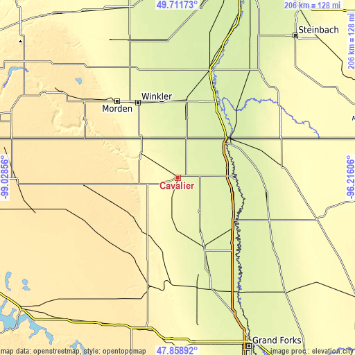
These maps also provides idea of topography and contour of this city, they are displayed at different zoom levels. More info about maps, scale and edge coordinates you can find below images.
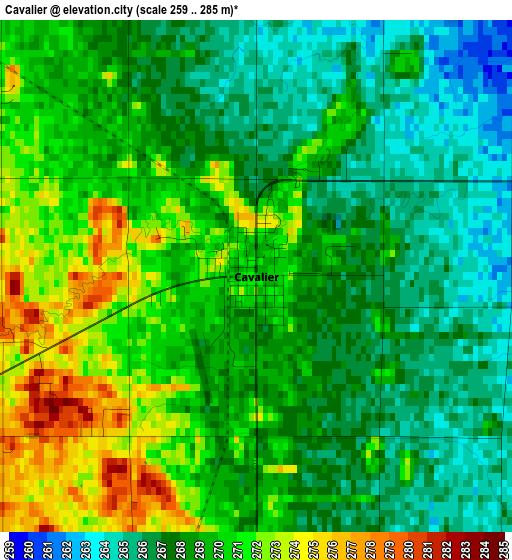
| \ | Map #1 | Topo.Map |
| Scale [m] | 259..285 m | × |
| Scale [ft] | 850..935 ft | × |
| Average | 268.6 m = 881 ft | × |
| Width | 6.44 km = 4 mi | 206 km = 128 mi |
| Height | 6.44 km = 4 mi | 206 km = 128 mi |
| ↑Max Latitude | 48.822821° | 49.71173° |
| Latitude at center | 48.79388° | 48.79388° |
| ↓Min Latitude | 48.764922° | 47.85892° |
| ← Min Longitude | -97.666255° | -99.02856° |
| Longitude center | -97.62231° | -97.62231° |
| →Max Longitude | -97.578365° | -96.21606° |
Nearby cities:
Cities around Cavalier sort by population:
• Grand Forks elevation 256 m
105.9 km,  155°
155°
• East Grand Forks 254 m
105.7 km, 155°
• Devils Lake 439 m
118.9 km,  230°
230°
• Grafton 252 m
45.2 km, 159°
• Grand Forks Air Force Base 271 m
94.9 km,  169°
169°
• Langdon 493 m
54.8 km,  266°
266°
• Warren 260 m
91.3 km,  136°
136°
• Park River 301 m
44.8 km,  191°
191°
• Larimore 347 m
98.7 km,  180°
180°
• Thompson 264 m
119.6 km, 161°
• Hallock 248 m
49.6 km,  92°
92°
• Lakota 461 m
98.7 km,  212°
212°
Multilingual:
 En español:
Cavalier elevación 269 m.
 En France:
Cavalier élévation 269 m.
 Auf Deutsch:
Cavalier höhe über dem Meeresspiegel ist 269 m.

Sources and notes:
- [note 1] Map square and city borders are not equal. Map elevation data is calculated only from area inside that square.
- [src 1] Elevation data from geonames database provided with same terms of usage.
- [src 2] The elevation map of Cavalier is generated using elevation data from NASA's 3 arcsec (90m) resolution SRTM data.
- [src 3] Base (background) map © OpenStreetMap contributors tiles are generated by Geofabrik and OpenTopoMap.
Copyright & License:
This Cavalier Elevation Map is licensed under CC BY-SA. You may reuse any part from this page, if you give a proper credit by linking to this URL:
 More info on terms of use page.