Wadena elevation
Wadena (Minnesota, Wadena County), United States elevation is 412 meters and Wadena elevation in feet is 1352 ft above sea level [src 1]. Wadena is a seat of a second-order administrative division (feature code) with elevation that is 133 meters (436 ft) bigger than average city elevation in United States.
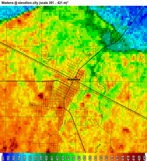
Below is the Elevation map of Wadena, which displays elevation range with different colors. Scale of the first map is from 391 to 421 m (1283 to 1381 ft) with average elevation of 408.1 meters (=1339 ft) [note 1]
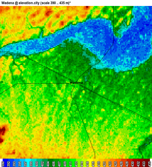
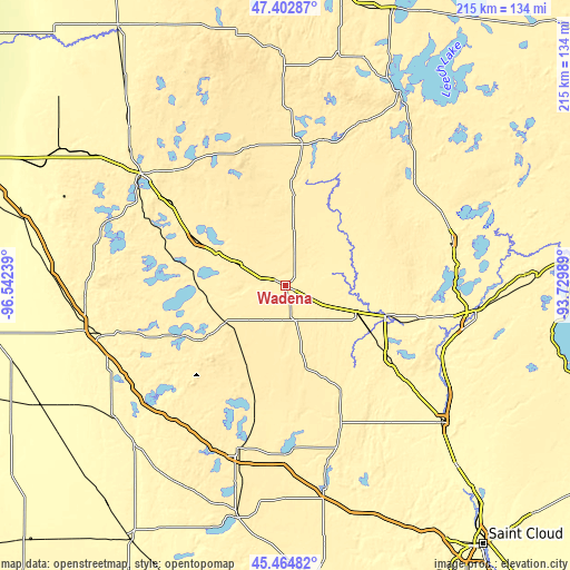
These maps also provides idea of topography and contour of this city, they are displayed at different zoom levels. More info about maps, scale and edge coordinates you can find below images.
| \ | Map #1 | Map #2 | Topo.Map |
| Scale [m] | 391..421 m | 390..435 m | × |
| Scale [ft] | 1283..1381 ft | 1280..1427 ft | × |
| Average | 408.1 m = 1339 ft | 409.4 m = 1343 ft | × |
| Width | 6.73 km = 4.2 mi | 13.47 km = 8.4 mi | 215.5 km = 133.9 mi |
| Height | 6.73 km = 4.2 mi | 13.47 km = 8.4 mi | 215.5 km = 133.9 mi |
| ↑Max Latitude | 46.472734° | 46.50299° | 47.40287° |
| Latitude at center | 46.44246° | 46.44246° | 46.44246° |
| ↓Min Latitude | 46.41217° | 46.381862° | 45.46482° |
| ← Min Longitude | -95.180085° | -95.224031° | -96.54239° |
| Longitude center | -95.13614° | -95.13614° | -95.13614° |
| →Max Longitude | -95.092195° | -95.048249° | -93.72989° |
Nearby cities:
Cities around Wadena sort by population:
• Alexandria elevation 429 m
64.7 km,  196°
196°
• Park Rapids 437 m
53.7 km,  6°
6°
• Long Prairie 392 m
56 km,  158°
158°
• Perham 416 m
37.4 km,  296°
296°
• Staples 391 m
28.1 km,  110°
110°
• Osakis 414 m
64 km,  181°
181°
• Frazee 423 m
53.6 km,  306°
306°
• Menahga 428 m
34.7 km,  4°
4°
• New York Mills 431 m
20.2 km,  294°
294°
• Lake Shore 383 m
59.6 km,  85°
85°
• East Gull Lake 385 m
59.9 km, 93°
• Parkers Prairie 447 m
35.4 km, 204°
Multilingual:
 En español:
Wadena elevación 412 m.
 En France:
Wadena élévation 412 m.


Sources and notes:
- [note 1] Map square and city borders are not equal. Map elevation data is calculated only from area inside that square.
- [src 1] Elevation data from geonames database provided with same terms of usage.
- [src 2] The elevation map of Wadena is generated using elevation data from NASA's 3 arcsec (90m) resolution SRTM data.
- [src 3] Base (background) map © OpenStreetMap contributors tiles are generated by Geofabrik and OpenTopoMap.
Copyright & License:
This Wadena Elevation Map is licensed under CC BY-SA. You may reuse any part from this page, if you give a proper credit by linking to this URL:
 More info on terms of use page.