Menahga elevation
Menahga (Minnesota, Wadena County), United States elevation is 428 meters and Menahga elevation in feet is 1404 ft above sea level [src 1]. Menahga is a populated place (feature code) with elevation that is 149 meters (489 ft) bigger than average city elevation in United States.
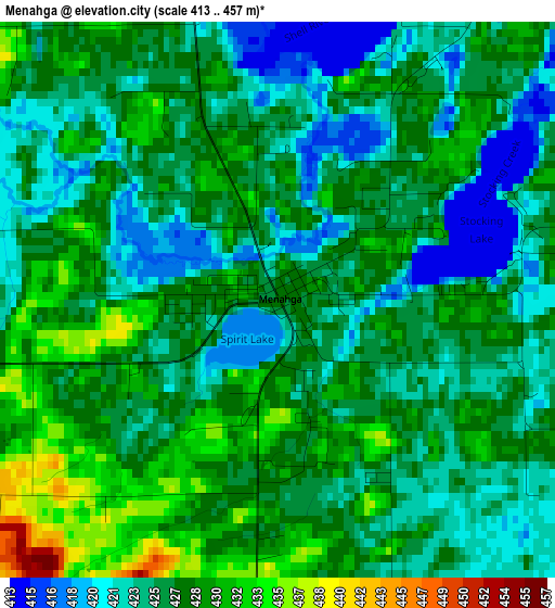
Below is the Elevation map of Menahga, which displays elevation range with different colors. Scale of the first map is from 413 to 457 m (1355 to 1499 ft) with average elevation of 426.1 meters (=1398 ft) [note 1]
These maps also provides idea of topography and contour of this city, they are displayed at different zoom levels. More info about maps, scale and edge coordinates you can find below images.
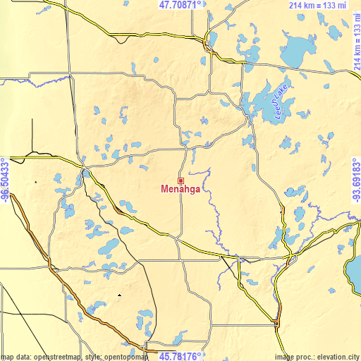
| \ | Map #1 | Topo.Map |
| Scale [m] | 413..457 m | × |
| Scale [ft] | 1355..1499 ft | × |
| Average | 426.1 m = 1398 ft | × |
| Width | 6.7 km = 4.2 mi | 214.3 km = 133.2 mi |
| Height | 6.7 km = 4.2 mi | 214.2 km = 133.1 mi |
| ↑Max Latitude | 46.78395° | 47.70871° |
| Latitude at center | 46.75385° | 46.75385° |
| ↓Min Latitude | 46.723733° | 45.78176° |
| ← Min Longitude | -95.142025° | -96.50433° |
| Longitude center | -95.09808° | -95.09808° |
| →Max Longitude | -95.054135° | -93.69183° |
Nearby cities:
Cities around Menahga sort by population:
• Detroit Lakes elevation 418 m
57.3 km,  277°
277°
• Wadena 412 m
34.7 km,  184°
184°
• Park Rapids 437 m
19 km,  9°
9°
• Perham 416 m
40.3 km,  243°
243°
• Staples 391 m
50.1 km,  152°
152°
• Pequot Lakes 392 m
62.5 km,  105°
105°
• Nisswa 374 m
67 km, 112°
• Frazee 423 m
46 km,  266°
266°
• New York Mills 431 m
33.7 km,  218°
218°
• Lake Shore 383 m
63.7 km,  117°
117°
• East Gull Lake 385 m
68.5 km, 124°
• Walker 402 m
54.8 km,  45°
45°
Multilingual:
 En español:
Menahga elevación 428 m.
 En France:
Menahga élévation 428 m.


Sources and notes:
- [note 1] Map square and city borders are not equal. Map elevation data is calculated only from area inside that square.
- [src 1] Elevation data from geonames database provided with same terms of usage.
- [src 2] The elevation map of Menahga is generated using elevation data from NASA's 3 arcsec (90m) resolution SRTM data.
- [src 3] Base (background) map © OpenStreetMap contributors tiles are generated by Geofabrik and OpenTopoMap.
Copyright & License:
This Menahga Elevation Map is licensed under CC BY-SA. You may reuse any part from this page, if you give a proper credit by linking to this URL:
 More info on terms of use page.