North Branch elevation
North Branch (Minnesota, Chisago County), United States elevation is 271 meters and North Branch elevation in feet is 889 ft above sea level [src 1]. North Branch is a populated place (feature code) with elevation that is 8 meters (26 ft) smaller than average city elevation in United States.
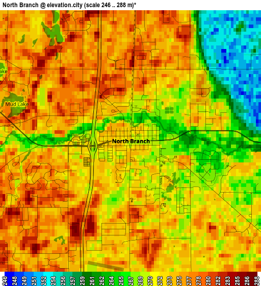
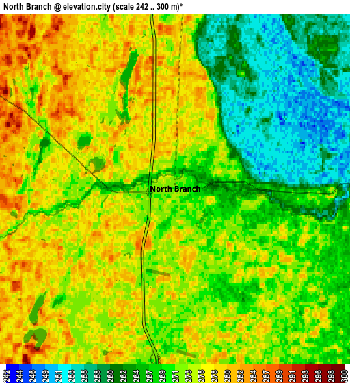
Below is the Elevation map of North Branch, which displays elevation range with different colors. Scale of the first map is from 246 to 288 m (807 to 945 ft) with average elevation of 272.1 meters (=893 ft) [note 1]
These maps also provides idea of topography and contour of this city, they are displayed at different zoom levels. More info about maps, scale and edge coordinates you can find below images.
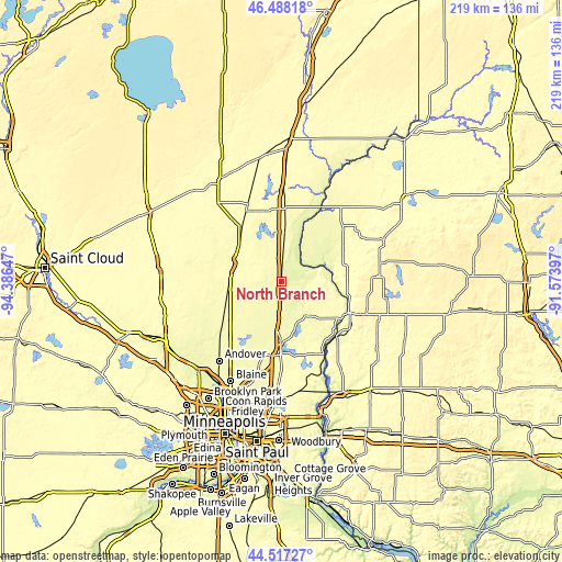
| \ | Map #1 | Map #2 | Topo.Map |
| Scale [m] | 246..288 m | 242..300 m | × |
| Scale [ft] | 807..945 ft | 794..984 ft | × |
| Average | 272.1 m = 893 ft | 271.2 m = 890 ft | × |
| Width | 6.85 km = 4.3 mi | 13.7 km = 8.5 mi | 219.1 km = 136.1 mi |
| Height | 6.85 km = 4.3 mi | 13.7 km = 8.5 mi | 219.1 km = 136.1 mi |
| ↑Max Latitude | 45.542137° | 45.572907° | 46.48818° |
| Latitude at center | 45.51135° | 45.51135° | 45.51135° |
| ↓Min Latitude | 45.480546° | 45.449725° | 44.51727° |
| ← Min Longitude | -93.024165° | -93.068111° | -94.38647° |
| Longitude center | -92.98022° | -92.98022° | -92.98022° |
| →Max Longitude | -92.936275° | -92.892329° | -91.57397° |
Nearby cities:
Cities around North Branch sort by population:
• Forest Lake elevation 276 m
25.9 km,  180°
180°
• Cambridge 291 m
20.2 km,  289°
289°
• Wyoming 272 m
19.5 km, 183°
• Isanti 283 m
21 km,  263°
263°
• Chisago City 280 m
16.9 km,  155°
155°
• Lindstrom 283 m
17 km,  142°
142°
• Rush City 280 m
19.4 km,  3°
3°
• Branch 274 m
3.2 km,  153°
153°
• Stacy 274 m
12.6 km, 182°
• Harris 273 m
8.4 km, 2°
• Shafer 286 m
22.8 km,  127°
127°
• Center City 284 m
18.3 km, 135°
Multilingual:
 En español:
North Branch elevación 271 m.
 En France:
North Branch élévation 271 m.
 Auf Deutsch:
North Branch höhe über dem Meeresspiegel ist 271 m.

Sources and notes:
- [note 1] Map square and city borders are not equal. Map elevation data is calculated only from area inside that square.
- [src 1] Elevation data from geonames database provided with same terms of usage.
- [src 2] The elevation map of North Branch is generated using elevation data from NASA's 3 arcsec (90m) resolution SRTM data.
- [src 3] Base (background) map © OpenStreetMap contributors tiles are generated by Geofabrik and OpenTopoMap.
Copyright & License:
This North Branch Elevation Map is licensed under CC BY-SA. You may reuse any part from this page, if you give a proper credit by linking to this URL:
 More info on terms of use page.