Monticello elevation
Monticello (Minnesota, Wright County), United States elevation is 281 meters and Monticello elevation in feet is 922 ft above sea level [src 1]. Monticello is a populated place (feature code) with elevation that is 2 meters (7 ft) bigger than average city elevation in United States.
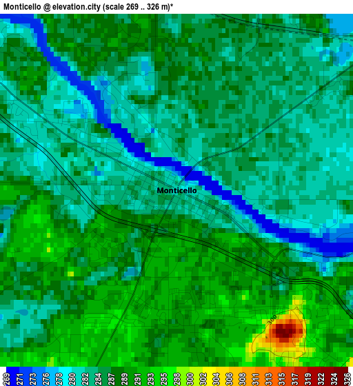
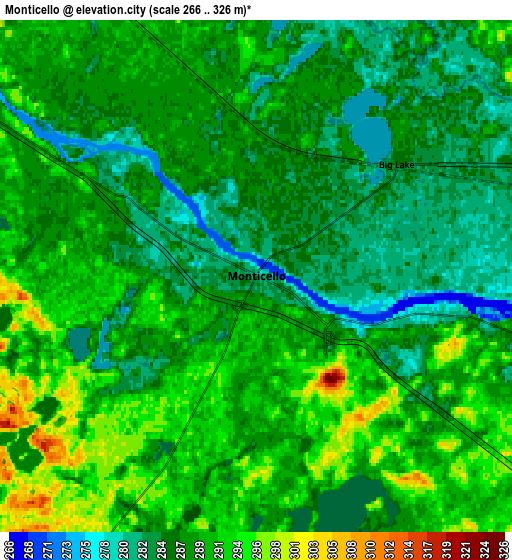
Below is the Elevation map of Monticello, which displays elevation range with different colors. Scale of the first map is from 269 to 326 m (883 to 1070 ft) with average elevation of 286 meters (=938 ft) [note 1]
These maps also provides idea of topography and contour of this city, they are displayed at different zoom levels. More info about maps, scale and edge coordinates you can find below images.
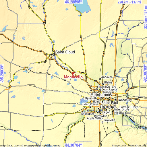
| \ | Map #1 | Map #2 | Topo.Map |
| Scale [m] | 269..326 m | 266..326 m | × |
| Scale [ft] | 883..1070 ft | 873..1070 ft | × |
| Average | 286 m = 938 ft | 288.1 m = 945 ft | × |
| Width | 6.87 km = 4.3 mi | 13.75 km = 8.5 mi | 219.9 km = 136.6 mi |
| Height | 6.87 km = 4.3 mi | 13.75 km = 8.5 mi | 219.9 km = 136.6 mi |
| ↑Max Latitude | 45.336419° | 45.367302° | 46.28595° |
| Latitude at center | 45.30552° | 45.30552° | 45.30552° |
| ↓Min Latitude | 45.274604° | 45.243671° | 44.30784° |
| ← Min Longitude | -93.838085° | -93.882031° | -95.20039° |
| Longitude center | -93.79414° | -93.79414° | -93.79414° |
| →Max Longitude | -93.750195° | -93.706249° | -92.38789° |
Nearby cities:
Cities around Monticello sort by population:
• Elk River elevation 270 m
17.8 km,  90°
90°
• Saint Michael 293 m
14.7 km,  136°
136°
• Buffalo 282 m
16.1 km,  203°
203°
• Otsego 267 m
16.2 km,  102°
102°
• Rogers 289 m
22.9 km,  124°
124°
• Big Lake 286 m
4.8 km,  51°
51°
• Albertville 291 m
13.3 km, 124°
• Zimmerman 301 m
22.1 km, 46°
• Dayton 264 m
22.9 km,  107°
107°
• Becker 297 m
11.7 km,  326°
326°
• Hanover 278 m
19.4 km,  148°
148°
• Maple Lake 320 m
18.3 km,  242°
242°
Multilingual:
 En español:
Monticello elevación 281 m.
 En France:
Monticello élévation 281 m.
 Auf Deutsch:
Monticello höhe über dem Meeresspiegel ist 281 m.

Sources and notes:
- [note 1] Map square and city borders are not equal. Map elevation data is calculated only from area inside that square.
- [src 1] Elevation data from geonames database provided with same terms of usage.
- [src 2] The elevation map of Monticello is generated using elevation data from NASA's 3 arcsec (90m) resolution SRTM data.
- [src 3] Base (background) map © OpenStreetMap contributors tiles are generated by Geofabrik and OpenTopoMap.
Copyright & License:
This Monticello Elevation Map is licensed under CC BY-SA. You may reuse any part from this page, if you give a proper credit by linking to this URL:
 More info on terms of use page.