Stambaugh, Iron River elevation
Stambaugh, Iron River (Michigan, Iron County), United States elevation is 497 meters and Stambaugh, Iron River elevation in feet is 1631 ft above sea level [src 1]. Stambaugh, Iron River is a section of populated place (feature code) with elevation that is 218 meters (715 ft) bigger than average city elevation in United States.
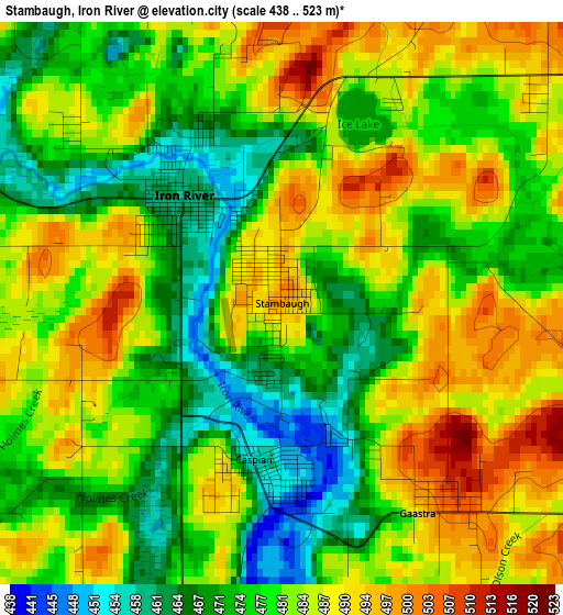
Below is the Elevation map of Stambaugh, Iron River, which displays elevation range with different colors. Scale of the first map is from 438 to 523 m (1437 to 1716 ft) with average elevation of 480.5 meters (=1576 ft) [note 1]
These maps also provides idea of topography and contour of this city, they are displayed at different zoom levels. More info about maps, scale and edge coordinates you can find below images.
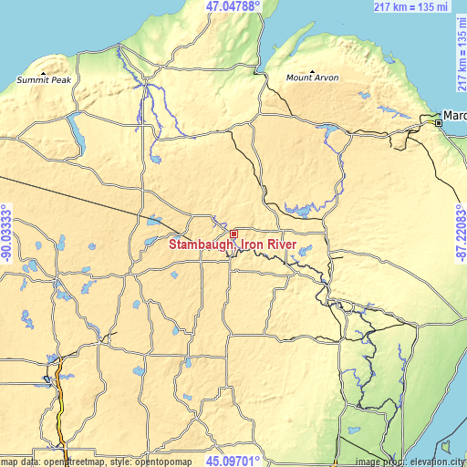
| \ | Map #1 | Topo.Map |
| Scale [m] | 438..523 m | × |
| Scale [ft] | 1437..1716 ft | × |
| Average | 480.5 m = 1576 ft | × |
| Width | 6.78 km = 4.2 mi | 216.9 km = 134.8 mi |
| Height | 6.78 km = 4.2 mi | 216.9 km = 134.8 mi |
| ↑Max Latitude | 46.111544° | 47.04788° |
| Latitude at center | 46.08107° | 46.08107° |
| ↓Min Latitude | 46.050579° | 45.09701° |
| ← Min Longitude | -88.671025° | -90.03333° |
| Longitude center | -88.62708° | -88.62708° |
| →Max Longitude | -88.583135° | -87.22083° |
Nearby cities:
Cities around Stambaugh, Iron River sort by population:
• Iron Mountain elevation 344 m
52.2 km,  123°
123°
• Kingsford 332 m
53.4 km,  126°
126°
• Iron River 458 m
1.8 km,  317°
317°
• Norway 291 m
64.8 km, 120°
• L'Anse 187 m
76.3 km,  10°
10°
• Crandon 497 m
60.5 km,  200°
200°
• Niagara 268 m
59.8 km, 125°
• Crystal Falls 448 m
22.7 km,  85°
85°
• Eagle River 504 m
51 km,  249°
249°
• Quinnesec 316 m
58.1 km, 121°
• Nashville 519 m
69.3 km,  206°
206°
• Florence 391 m
33.9 km, 121°
Multilingual:
 En español:
Stambaugh, Iron River elevación 497 m.
 En France:
Stambaugh, Iron River élévation 497 m.
 Auf Deutsch:
Stambaugh, Iron River höhe über dem Meeresspiegel ist 497 m.
 На русском:
Stambaugh, Iron River высота над уровнем моря 497 м
Sources and notes:
- [note 1] Map square and city borders are not equal. Map elevation data is calculated only from area inside that square.
- [src 1] Elevation data from geonames database provided with same terms of usage.
- [src 2] The elevation map of Stambaugh, Iron River is generated using elevation data from NASA's 3 arcsec (90m) resolution SRTM data.
- [src 3] Base (background) map © OpenStreetMap contributors tiles are generated by Geofabrik and OpenTopoMap.
Copyright & License:
This Stambaugh, Iron River Elevation Map is licensed under CC BY-SA. You may reuse any part from this page, if you give a proper credit by linking to this URL:
 More info on terms of use page.