Saranac elevation
Saranac (Michigan, Ionia County), United States elevation is 195 meters and Saranac elevation in feet is 640 ft above sea level [src 1]. Saranac is a populated place (feature code) with elevation that is 84 meters (276 ft) smaller than average city elevation in United States.
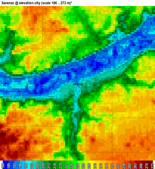
Below is the Elevation map of Saranac, which displays elevation range with different colors. Scale of the first map is from 186 to 273 m (610 to 896 ft) with average elevation of 228 meters (=748 ft) [note 1]
These maps also provides idea of topography and contour of this city, they are displayed at different zoom levels. More info about maps, scale and edge coordinates you can find below images.
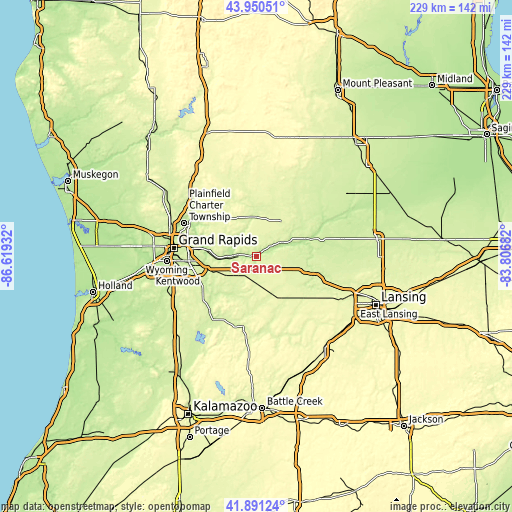
| \ | Map #1 | Topo.Map |
| Scale [m] | 186..273 m | × |
| Scale [ft] | 610..896 ft | × |
| Average | 228 m = 748 ft | × |
| Width | 7.16 km = 4.4 mi | 229 km = 142.3 mi |
| Height | 7.16 km = 4.4 mi | 229 km = 142.3 mi |
| ↑Max Latitude | 42.961648° | 43.95051° |
| Latitude at center | 42.92948° | 42.92948° |
| ↓Min Latitude | 42.897295° | 41.89124° |
| ← Min Longitude | -85.257015° | -86.61932° |
| Longitude center | -85.21307° | -85.21307° |
| →Max Longitude | -85.169125° | -83.80682° |
Nearby cities:
Cities around Saranac sort by population:
• Forest Hills elevation 198 m
22.8 km,  278°
278°
• Northview 229 m
34.1 km,  292°
292°
• Ionia 217 m
13.2 km,  60°
60°
• East Grand Rapids 232 m
32.3 km,  272°
272°
• Greenville 258 m
27.8 km,  353°
353°
• Hastings 249 m
32.2 km,  191°
191°
• Belding 236 m
18.8 km,  356°
356°
• Portland 223 m
26.1 km,  104°
104°
• Lowell 194 m
10.5 km, 272°
• Middleville 232 m
31.5 km,  220°
220°
• Lake Odessa 266 m
17.2 km,  159°
159°
• Caledonia 247 m
29.3 km,  237°
237°
Multilingual:
 En español:
Saranac elevación 195 m.
 En France:
Saranac élévation 195 m.


Sources and notes:
- [note 1] Map square and city borders are not equal. Map elevation data is calculated only from area inside that square.
- [src 1] Elevation data from geonames database provided with same terms of usage.
- [src 2] The elevation map of Saranac is generated using elevation data from NASA's 3 arcsec (90m) resolution SRTM data.
- [src 3] Base (background) map © OpenStreetMap contributors tiles are generated by Geofabrik and OpenTopoMap.
Copyright & License:
This Saranac Elevation Map is licensed under CC BY-SA. You may reuse any part from this page, if you give a proper credit by linking to this URL:
 More info on terms of use page.