Ionia elevation
Ionia (Michigan, Ionia County), United States elevation is 217 meters and Ionia elevation in feet is 712 ft above sea level [src 1]. Ionia is a seat of a second-order administrative division (feature code) with elevation that is 62 meters (203 ft) smaller than average city elevation in United States.
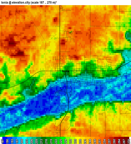
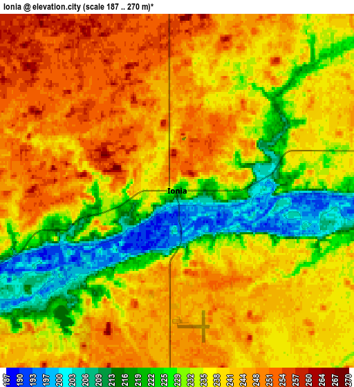
Below is the Elevation map of Ionia, which displays elevation range with different colors. Scale of the first map is from 187 to 270 m (614 to 886 ft) with average elevation of 230.4 meters (=756 ft) [note 1]
These maps also provides idea of topography and contour of this city, they are displayed at different zoom levels. More info about maps, scale and edge coordinates you can find below images.
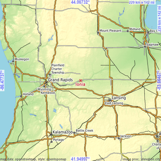
| \ | Map #1 | Map #2 | Topo.Map |
| Scale [m] | 187..270 m | 187..270 m | × |
| Scale [ft] | 614..886 ft | 614..886 ft | × |
| Average | 230.4 m = 756 ft | 236.4 m = 776 ft | × |
| Width | 7.15 km = 4.4 mi | 14.3 km = 8.9 mi | 228.8 km = 142.2 mi |
| Height | 7.15 km = 4.4 mi | 14.3 km = 8.9 mi | 228.7 km = 142.1 mi |
| ↑Max Latitude | 43.019388° | 43.051509° | 44.00732° |
| Latitude at center | 42.98725° | 42.98725° | 42.98725° |
| ↓Min Latitude | 42.955095° | 42.922924° | 41.94997° |
| ← Min Longitude | -85.115065° | -85.159011° | -86.47737° |
| Longitude center | -85.07112° | -85.07112° | -85.07112° |
| →Max Longitude | -85.027175° | -84.983229° | -83.66487° |
Nearby cities:
Cities around Ionia sort by population:
• Forest Hills elevation 198 m
34.2 km,  264°
264°
• Greenville 258 m
25.8 km,  325°
325°
• Grand Ledge 255 m
37.1 km,  134°
134°
• Belding 236 m
17.8 km,  313°
313°
• Portland 223 m
19 km, 133°
• Lowell 194 m
22.8 km,  254°
254°
• Lake Odessa 266 m
23.2 km,  193°
193°
• Wacousta 243 m
35 km,  120°
120°
• Stanton 283 m
34 km,  358°
358°
• Saranac 195 m
13.2 km,  240°
240°
• Fowler 228 m
27 km,  86°
86°
• Carson City 234 m
27.9 km,  40°
40°
Multilingual:
 En español:
Ionia elevación 217 m.
 En France:
Ionia élévation 217 m.


Sources and notes:
- [note 1] Map square and city borders are not equal. Map elevation data is calculated only from area inside that square.
- [src 1] Elevation data from geonames database provided with same terms of usage.
- [src 2] The elevation map of Ionia is generated using elevation data from NASA's 3 arcsec (90m) resolution SRTM data.
- [src 3] Base (background) map © OpenStreetMap contributors tiles are generated by Geofabrik and OpenTopoMap.
Copyright & License:
This Ionia Elevation Map is licensed under CC BY-SA. You may reuse any part from this page, if you give a proper credit by linking to this URL:
 More info on terms of use page.