Morenci elevation
Morenci (Michigan, Lenawee County), United States elevation is 234 meters and Morenci elevation in feet is 768 ft above sea level [src 1]. Morenci is a populated place (feature code) with elevation that is 45 meters (148 ft) smaller than average city elevation in United States.
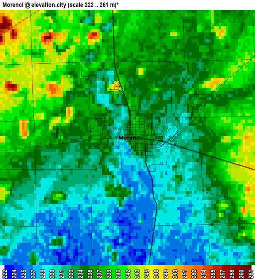
Below is the Elevation map of Morenci, which displays elevation range with different colors. Scale of the first map is from 222 to 261 m (728 to 856 ft) with average elevation of 234.5 meters (=769 ft) [note 1]
These maps also provides idea of topography and contour of this city, they are displayed at different zoom levels. More info about maps, scale and edge coordinates you can find below images.
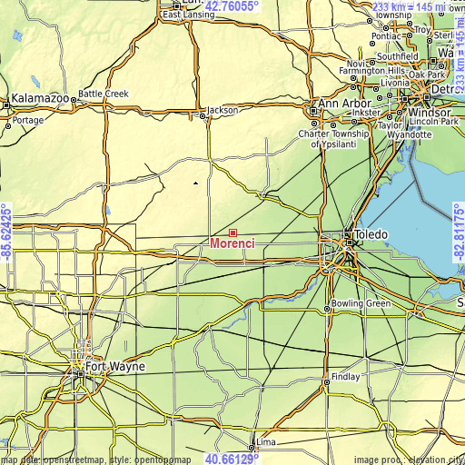
| \ | Map #1 | Topo.Map |
| Scale [m] | 222..261 m | × |
| Scale [ft] | 728..856 ft | × |
| Average | 234.5 m = 769 ft | × |
| Width | 7.29 km = 4.5 mi | 233.4 km = 145 mi |
| Height | 7.29 km = 4.5 mi | 233.4 km = 145 mi |
| ↑Max Latitude | 41.752283° | 42.76055° |
| Latitude at center | 41.71949° | 41.71949° |
| ↓Min Latitude | 41.68668° | 40.66129° |
| ← Min Longitude | -84.261945° | -85.62425° |
| Longitude center | -84.218° | -84.218° |
| →Max Longitude | -84.174055° | -82.81175° |
Nearby cities:
Cities around Morenci sort by population:
• Adrian elevation 238 m
24.8 km,  37°
37°
• Wauseon 234 m
20 km,  161°
161°
• Archbold 223 m
23.2 km,  198°
198°
• Swanton 208 m
30.8 km,  118°
118°
• Delta 221 m
24 km,  132°
132°
• Burlington 217 m
18 km, 204°
• Hudson 282 m
18.8 km,  323°
323°
• Manitou Beach-Devils Lake 316 m
29 km,  348°
348°
• West Unity 241 m
23.3 km,  230°
230°
• Pioneer 269 m
28.2 km,  261°
261°
• Stryker 217 m
29 km,  214°
214°
• Fayette 240 m
10.4 km,  240°
240°
Multilingual:
 En español:
Morenci elevación 234 m.
 En France:
Morenci élévation 234 m.


Sources and notes:
- [note 1] Map square and city borders are not equal. Map elevation data is calculated only from area inside that square.
- [src 1] Elevation data from geonames database provided with same terms of usage.
- [src 2] The elevation map of Morenci is generated using elevation data from NASA's 3 arcsec (90m) resolution SRTM data.
- [src 3] Base (background) map © OpenStreetMap contributors tiles are generated by Geofabrik and OpenTopoMap.
Copyright & License:
This Morenci Elevation Map is licensed under CC BY-SA. You may reuse any part from this page, if you give a proper credit by linking to this URL:
 More info on terms of use page.