Hancock elevation
Hancock (Michigan, Houghton County), United States elevation is 210 meters and Hancock elevation in feet is 689 ft above sea level [src 1]. Hancock is a populated place (feature code) with elevation that is 69 meters (226 ft) smaller than average city elevation in United States.
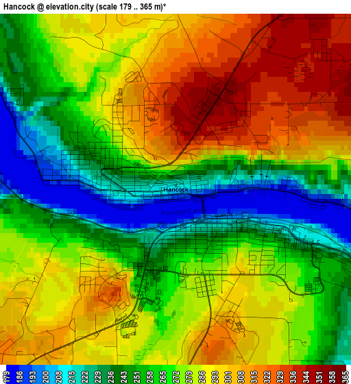
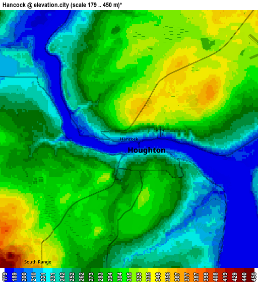
Below is the Elevation map of Hancock, which displays elevation range with different colors. Scale of the first map is from 179 to 365 m (587 to 1198 ft) with average elevation of 275.2 meters (=903 ft) [note 1]
These maps also provides idea of topography and contour of this city, they are displayed at different zoom levels. More info about maps, scale and edge coordinates you can find below images.
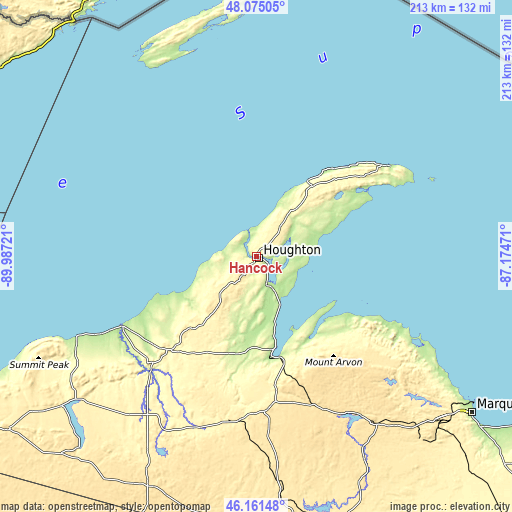
| \ | Map #1 | Map #2 | Topo.Map |
| Scale [m] | 179..365 m | 179..450 m | × |
| Scale [ft] | 587..1198 ft | 587..1476 ft | × |
| Average | 275.2 m = 903 ft | 271.5 m = 891 ft | × |
| Width | 6.65 km = 4.1 mi | 13.3 km = 8.3 mi | 212.8 km = 132.2 mi |
| Height | 6.65 km = 4.1 mi | 13.3 km = 8.3 mi | 212.8 km = 132.2 mi |
| ↑Max Latitude | 47.156761° | 47.186635° | 48.07505° |
| Latitude at center | 47.12687° | 47.12687° | 47.12687° |
| ↓Min Latitude | 47.096962° | 47.067038° | 46.16148° |
| ← Min Longitude | -88.624905° | -88.668851° | -89.98721° |
| Longitude center | -88.58096° | -88.58096° | -88.58096° |
| →Max Longitude | -88.537015° | -88.493069° | -87.17471° |
Nearby cities:
Cities around Hancock sort by population:
• Marquette elevation 201 m
111.1 km,  125°
125°
• Houghton 197 m
1.1 km,  121°
121°
• Ishpeming 431 m
99.3 km,  135°
135°
• Negaunee 416 m
101.5 km, 133°
• West Ishpeming 437 m
98 km, 136°
• Trowbridge Park 238 m
107.6 km, 126°
• Baraga 190 m
39.4 km,  169°
169°
• Laurium 377 m
16.1 km,  40°
40°
• L'Anse 187 m
42.3 km, 166°
• Ontonagon 186 m
62.4 km,  242°
242°
• Dollar Bay 193 m
5.3 km,  98°
98°
• Eagle River 193 m
38.5 km,  34°
34°
Multilingual:
 En español:
Hancock elevación 210 m.
 En France:
Hancock élévation 210 m.


Sources and notes:
- [note 1] Map square and city borders are not equal. Map elevation data is calculated only from area inside that square.
- [src 1] Elevation data from geonames database provided with same terms of usage.
- [src 2] The elevation map of Hancock is generated using elevation data from NASA's 3 arcsec (90m) resolution SRTM data.
- [src 3] Base (background) map © OpenStreetMap contributors tiles are generated by Geofabrik and OpenTopoMap.
Copyright & License:
This Hancock Elevation Map is licensed under CC BY-SA. You may reuse any part from this page, if you give a proper credit by linking to this URL:
 More info on terms of use page.