Ishpeming elevation
Ishpeming (Michigan, Marquette County), United States elevation is 431 meters and Ishpeming elevation in feet is 1414 ft above sea level [src 1]. Ishpeming is a populated place (feature code) with elevation that is 152 meters (499 ft) bigger than average city elevation in United States.
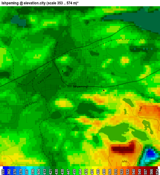
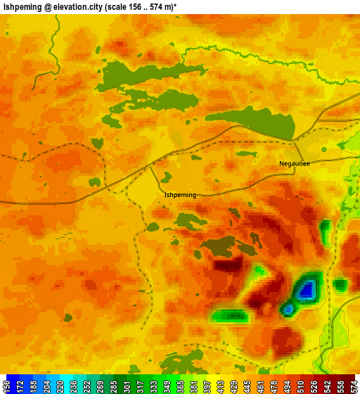
Below is the Elevation map of Ishpeming, which displays elevation range with different colors. Scale of the first map is from 353 to 574 m (1158 to 1883 ft) with average elevation of 450.4 meters (=1478 ft) [note 1]
These maps also provides idea of topography and contour of this city, they are displayed at different zoom levels. More info about maps, scale and edge coordinates you can find below images.
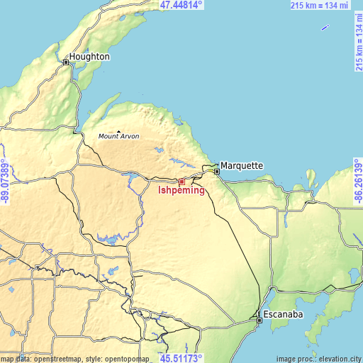
| \ | Map #1 | Map #2 | Topo.Map |
| Scale [m] | 353..574 m | 156..574 m | × |
| Scale [ft] | 1158..1883 ft | 512..1883 ft | × |
| Average | 450.4 m = 1478 ft | 444.5 m = 1458 ft | × |
| Width | 6.73 km = 4.2 mi | 13.46 km = 8.4 mi | 215.3 km = 133.8 mi |
| Height | 6.73 km = 4.2 mi | 13.46 km = 8.4 mi | 215.3 km = 133.8 mi |
| ↑Max Latitude | 46.518798° | 46.549029° | 47.44814° |
| Latitude at center | 46.48855° | 46.48855° | 46.48855° |
| ↓Min Latitude | 46.458285° | 46.428004° | 45.51173° |
| ← Min Longitude | -87.711585° | -87.755531° | -89.07389° |
| Longitude center | -87.66764° | -87.66764° | -87.66764° |
| →Max Longitude | -87.623695° | -87.579749° | -86.26139° |
Nearby cities:
Cities around Ishpeming sort by population:
• Marquette elevation 201 m
21.7 km,  73°
73°
• Negaunee 416 m
4.4 km, 74°
• West Ishpeming 437 m
2.6 km,  257°
257°
• K. I. Sawyer Air Force Base 362 m
26.7 km,  126°
126°
• Munising 179 m
78.5 km,  96°
96°
• Trowbridge Park 238 m
19.2 km, 66°
• Baraga 190 m
70.5 km,  297°
297°
• L'Anse 187 m
67 km, 296°
• Gwinn 331 m
28.9 km,  142°
142°
• Crystal Falls 448 m
67.1 km,  229°
229°
• Harvey 194 m
24 km,  88°
88°
• Florence 391 m
77.4 km,  215°
215°
Multilingual:
 En español:
Ishpeming elevación 431 m.
 En France:
Ishpeming élévation 431 m.
 Auf Deutsch:
Ishpeming höhe über dem Meeresspiegel ist 431 m.

Sources and notes:
- [note 1] Map square and city borders are not equal. Map elevation data is calculated only from area inside that square.
- [src 1] Elevation data from geonames database provided with same terms of usage.
- [src 2] The elevation map of Ishpeming is generated using elevation data from NASA's 3 arcsec (90m) resolution SRTM data.
- [src 3] Base (background) map © OpenStreetMap contributors tiles are generated by Geofabrik and OpenTopoMap.
Copyright & License:
This Ishpeming Elevation Map is licensed under CC BY-SA. You may reuse any part from this page, if you give a proper credit by linking to this URL:
 More info on terms of use page.