Flint elevation
Flint (Michigan, Genesee County), United States elevation is 231 meters and Flint elevation in feet is 758 ft above sea level [src 1]. Flint is a seat of a second-order administrative division (feature code) with elevation that is 48 meters (157 ft) smaller than average city elevation in United States.
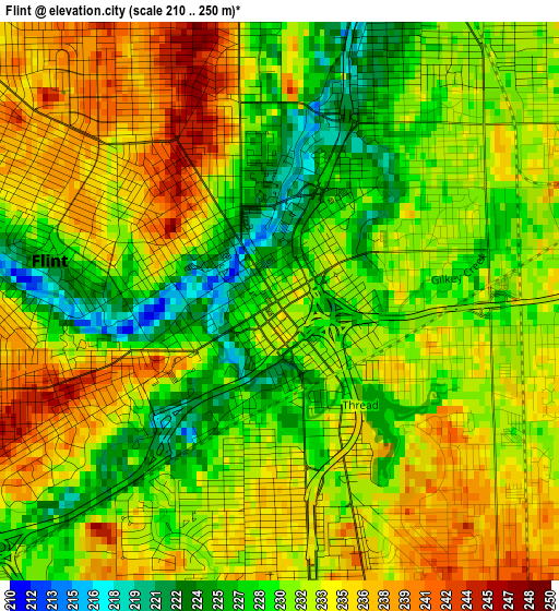
Below is the Elevation map of Flint, which displays elevation range with different colors. Scale of the first map is from 210 to 250 m (689 to 820 ft) with average elevation of 231.8 meters (=760 ft) [note 1]
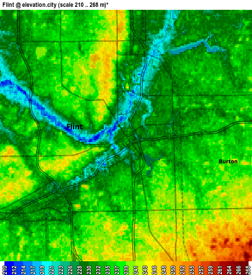
These maps also provides idea of topography and contour of this city, they are displayed at different zoom levels. More info about maps, scale and edge coordinates you can find below images.
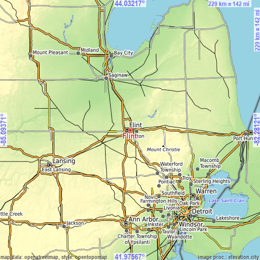
| \ | Map #1 | Map #2 | Topo.Map |
| Scale [m] | 210..250 m | 210..268 m | × |
| Scale [ft] | 689..820 ft | 689..879 ft | × |
| Average | 231.8 m = 760 ft | 234.8 m = 770 ft | × |
| Width | 7.15 km = 4.4 mi | 14.29 km = 8.9 mi | 228.7 km = 142.1 mi |
| Height | 7.15 km = 4.4 mi | 14.29 km = 8.9 mi | 228.7 km = 142.1 mi |
| ↑Max Latitude | 43.044655° | 43.076762° | 44.03217° |
| Latitude at center | 43.01253° | 43.01253° | 43.01253° |
| ↓Min Latitude | 42.980389° | 42.94823° | 41.97567° |
| ← Min Longitude | -83.731405° | -83.775351° | -85.09371° |
| Longitude center | -83.68746° | -83.68746° | -83.68746° |
| →Max Longitude | -83.643515° | -83.599569° | -82.28121° |
Nearby cities:
Cities around Flint sort by population:
• Burton elevation 239 m
6 km,  104°
104°
• Fenton 277 m
23.9 km,  183°
183°
• Beecher 245 m
8.6 km,  356°
356°
• Flushing 215 m
14.4 km,  292°
292°
• Grand Blanc 258 m
10.5 km,  153°
153°
• Swartz Creek 241 m
13.2 km,  242°
242°
• Lake Fenton 273 m
18.6 km,  185°
185°
• Davison 242 m
14 km,  79°
79°
• Linden 268 m
23.3 km,  199°
199°
• Mount Morris 235 m
11.8 km, 357°
• Clio 220 m
18.7 km,  348°
348°
• Goodrich 270 m
18.2 km,  125°
125°
Multilingual:
 En español:
Flint elevación 231 m.
 En France:
Flint élévation 231 m.


Sources and notes:
- [note 1] Map square and city borders are not equal. Map elevation data is calculated only from area inside that square.
- [src 1] Elevation data from geonames database provided with same terms of usage.
- [src 2] The elevation map of Flint is generated using elevation data from NASA's 3 arcsec (90m) resolution SRTM data.
- [src 3] Base (background) map © OpenStreetMap contributors tiles are generated by Geofabrik and OpenTopoMap.
Copyright & License:
This Flint Elevation Map is licensed under CC BY-SA. You may reuse any part from this page, if you give a proper credit by linking to this URL:
 More info on terms of use page.