Cassopolis elevation
Cassopolis (Michigan, Cass County), United States elevation is 272 meters and Cassopolis elevation in feet is 892 ft above sea level [src 1]. Cassopolis is a seat of a second-order administrative division (feature code) with elevation that is 7 meters (23 ft) smaller than average city elevation in United States.
Below is the Elevation map of Cassopolis, which displays elevation range with different colors. Scale of the first map is from 244 to 300 m (801 to 984 ft) with average elevation of 269 meters (=883 ft) [note 1]
These maps also provides idea of topography and contour of this city, they are displayed at different zoom levels. More info about maps, scale and edge coordinates you can find below images.
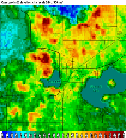
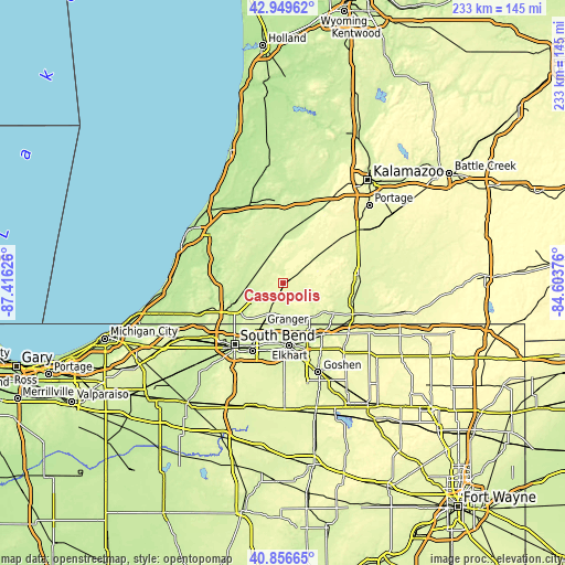
| \ | Map #1 | Topo.Map |
| Scale [m] | 244..300 m | × |
| Scale [ft] | 801..984 ft | × |
| Average | 269 m = 883 ft | × |
| Width | 7.27 km = 4.5 mi | 232.7 km = 144.6 mi |
| Height | 7.27 km = 4.5 mi | 232.7 km = 144.6 mi |
| ↑Max Latitude | 41.944405° | 42.94962° |
| Latitude at center | 41.91171° | 41.91171° |
| ↓Min Latitude | 41.878999° | 40.85665° |
| ← Min Longitude | -86.053955° | -87.41626° |
| Longitude center | -86.01001° | -86.01001° |
| →Max Longitude | -85.966065° | -84.60376° |
Nearby cities:
Cities around Cassopolis sort by population:
• Elkhart elevation 232 m
25.7 km,  173°
173°
• Granger 243 m
19.5 km,  205°
205°
• Niles 211 m
22.2 km,  245°
245°
• Dowagiac 234 m
11.5 km,  314°
314°
• Simonton Lake 245 m
17.7 km, 170°
• Georgetown 223 m
27.2 km,  221°
221°
• Osceola 229 m
28 km,  191°
191°
• Decatur 242 m
22 km,  7°
7°
• Berrien Springs 203 m
27.5 km,  278°
278°
• Bristol 237 m
26.5 km,  142°
142°
• Edwardsburg 253 m
14.2 km,  204°
204°
• Marcellus 275 m
20.5 km,  51°
51°
Multilingual:
 En español:
Cassopolis elevación 272 m.
 En France:
Cassopolis élévation 272 m.
 Auf Deutsch:
Cassopolis höhe über dem Meeresspiegel ist 272 m.

Sources and notes:
- [note 1] Map square and city borders are not equal. Map elevation data is calculated only from area inside that square.
- [src 1] Elevation data from geonames database provided with same terms of usage.
- [src 2] The elevation map of Cassopolis is generated using elevation data from NASA's 3 arcsec (90m) resolution SRTM data.
- [src 3] Base (background) map © OpenStreetMap contributors tiles are generated by Geofabrik and OpenTopoMap.
Copyright & License:
This Cassopolis Elevation Map is licensed under CC BY-SA. You may reuse any part from this page, if you give a proper credit by linking to this URL:
 More info on terms of use page.