Turner elevation
Turner (Maine, Androscoggin County), United States elevation is 97 meters and Turner elevation in feet is 318 ft above sea level [src 1]. Turner is a populated place (feature code) with elevation that is 182 meters (597 ft) smaller than average city elevation in United States.
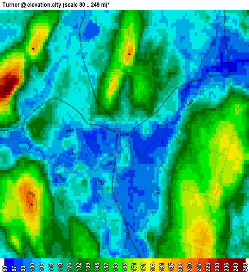
Below is the Elevation map of Turner, which displays elevation range with different colors. Scale of the first map is from 80 to 249 m (262 to 817 ft) with average elevation of 127.6 meters (=419 ft) [note 1]
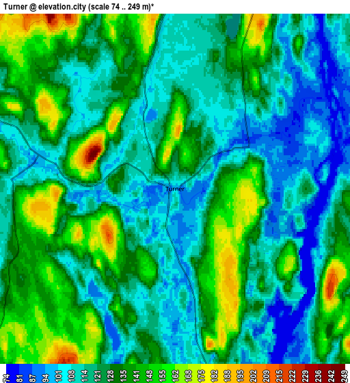
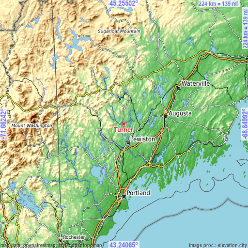
These maps also provides idea of topography and contour of this city, they are displayed at different zoom levels. More info about maps, scale and edge coordinates you can find below images.
| \ | Map #1 | Map #2 | Topo.Map |
| Scale [m] | 80..249 m | 74..249 m | × |
| Scale [ft] | 262..817 ft | 243..817 ft | × |
| Average | 127.6 m = 419 ft | 125.7 m = 412 ft | × |
| Width | 7 km = 4.3 mi | 14 km = 8.7 mi | 224 km = 139.2 mi |
| Height | 7 km = 4.3 mi | 14 km = 8.7 mi | 224 km = 139.2 mi |
| ↑Max Latitude | 44.287926° | 44.319376° | 45.25502° |
| Latitude at center | 44.25646° | 44.25646° | 44.25646° |
| ↓Min Latitude | 44.224977° | 44.193477° | 43.24065° |
| ← Min Longitude | -70.300115° | -70.344061° | -71.66242° |
| Longitude center | -70.25617° | -70.25617° | -70.25617° |
| →Max Longitude | -70.212225° | -70.168279° | -68.84992° |
Nearby cities:
Cities around Turner sort by population:
• Lewiston elevation 69 m
17.7 km,  169°
169°
• Auburn 58 m
17.7 km, 173°
• Sabattus 77 m
19.3 km,  142°
142°
• Greene 99 m
11.8 km,  128°
128°
• Monmouth 84 m
17.7 km,  96°
96°
• Mechanic Falls 87 m
19.4 km,  213°
213°
• Livermore 125 m
14.2 km,  2°
2°
• Leeds 89 m
12.1 km,  64°
64°
• Buckfield 114 m
9.4 km,  292°
292°
• Wayne 92 m
18.3 km, 55°
• Hebron 174 m
13.6 km,  241°
241°
• Hartford 141 m
14.8 km,  330°
330°
Multilingual:
 En español:
Turner elevación 97 m.
 En France:
Turner élévation 97 m.


Sources and notes:
- [note 1] Map square and city borders are not equal. Map elevation data is calculated only from area inside that square.
- [src 1] Elevation data from geonames database provided with same terms of usage.
- [src 2] The elevation map of Turner is generated using elevation data from NASA's 3 arcsec (90m) resolution SRTM data.
- [src 3] Base (background) map © OpenStreetMap contributors tiles are generated by Geofabrik and OpenTopoMap.
Copyright & License:
This Turner Elevation Map is licensed under CC BY-SA. You may reuse any part from this page, if you give a proper credit by linking to this URL:
 More info on terms of use page.