Auburn elevation
Auburn (Maine, Androscoggin County), United States elevation is 58 meters and Auburn elevation in feet is 190 ft above sea level [src 1]. Auburn is a seat of a second-order administrative division (feature code) with elevation that is 221 meters (725 ft) smaller than average city elevation in United States.
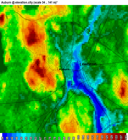
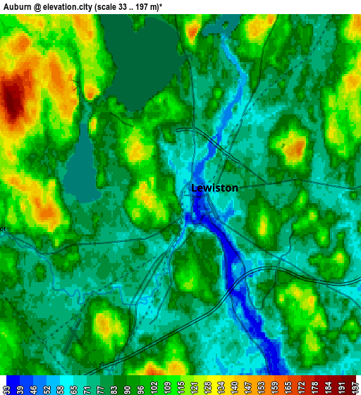
Below is the Elevation map of Auburn, which displays elevation range with different colors. Scale of the first map is from 34 to 141 m (112 to 463 ft) with average elevation of 79.3 meters (=260 ft) [note 1]
These maps also provides idea of topography and contour of this city, they are displayed at different zoom levels. More info about maps, scale and edge coordinates you can find below images.
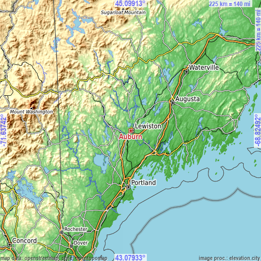
| \ | Map #1 | Map #2 | Topo.Map |
| Scale [m] | 34..141 m | 33..197 m | × |
| Scale [ft] | 112..463 ft | 108..646 ft | × |
| Average | 79.3 m = 260 ft | 89 m = 292 ft | × |
| Width | 7.02 km = 4.4 mi | 14.04 km = 8.7 mi | 224.6 km = 139.6 mi |
| Height | 7.02 km = 4.4 mi | 14.04 km = 8.7 mi | 224.6 km = 139.6 mi |
| ↑Max Latitude | 44.129401° | 44.160935° | 45.09913° |
| Latitude at center | 44.09785° | 44.09785° | 44.09785° |
| ↓Min Latitude | 44.066282° | 44.034697° | 43.07933° |
| ← Min Longitude | -70.275115° | -70.319061° | -71.63742° |
| Longitude center | -70.23117° | -70.23117° | -70.23117° |
| →Max Longitude | -70.187225° | -70.143279° | -68.82492° |
Nearby cities:
Cities around Auburn sort by population:
• Lewiston elevation 69 m
1.3 km,  78°
78°
• Lisbon 55 m
12.5 km,  126°
126°
• Turner 97 m
17.7 km,  353°
353°
• New Gloucester 103 m
15.6 km,  195°
195°
• Poland 102 m
13.6 km,  252°
252°
• Sabattus 77 m
10.2 km, 76°
• Greene 99 m
12.5 km,  35°
35°
• Lisbon Falls 32 m
17.7 km, 129°
• Minot 85 m
7.2 km,  259°
259°
• Mechanic Falls 87 m
12.9 km,  276°
276°
• Oxford 103 m
21.2 km, 280°
• Hebron 174 m
17.9 km,  308°
308°
Multilingual:
 En español:
Auburn elevación 58 m.
 En France:
Auburn élévation 58 m.


Sources and notes:
- [note 1] Map square and city borders are not equal. Map elevation data is calculated only from area inside that square.
- [src 1] Elevation data from geonames database provided with same terms of usage.
- [src 2] The elevation map of Auburn is generated using elevation data from NASA's 3 arcsec (90m) resolution SRTM data.
- [src 3] Base (background) map © OpenStreetMap contributors tiles are generated by Geofabrik and OpenTopoMap.
Copyright & License:
This Auburn Elevation Map is licensed under CC BY-SA. You may reuse any part from this page, if you give a proper credit by linking to this URL:
 More info on terms of use page.