Topsham elevation
Topsham (Maine, Sagadahoc County), United States elevation is 47 meters and Topsham elevation in feet is 154 ft above sea level [src 1]. Topsham is a populated place (feature code) with elevation that is 232 meters (761 ft) smaller than average city elevation in United States.
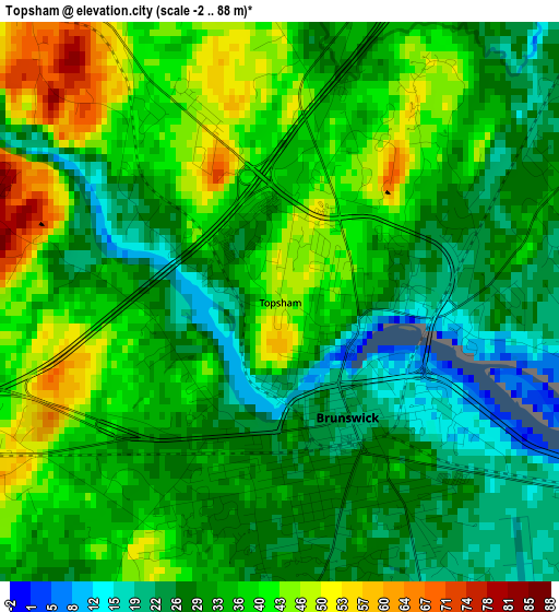
Below is the Elevation map of Topsham, which displays elevation range with different colors. Scale of the first map is from -2 to 88 m (-7 to 289 ft) with average elevation of 33.9 meters (=111 ft) [note 1]
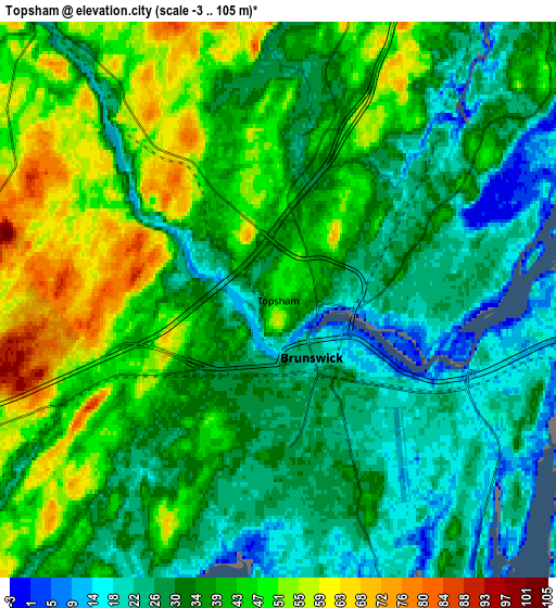
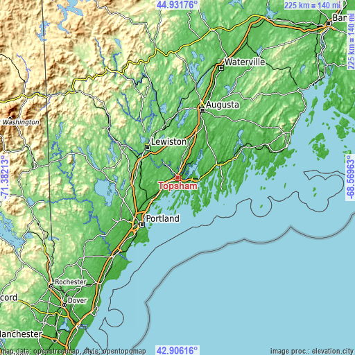
These maps also provides idea of topography and contour of this city, they are displayed at different zoom levels. More info about maps, scale and edge coordinates you can find below images.
| \ | Map #1 | Map #2 | Topo.Map |
| Scale [m] | -2..88 m | -3..105 m | × |
| Scale [ft] | -7..289 ft | -10..344 ft | × |
| Average | 33.9 m = 111 ft | 36.7 m = 120 ft | × |
| Width | 7.04 km = 4.4 mi | 14.08 km = 8.7 mi | 225.2 km = 139.9 mi |
| Height | 7.04 km = 4.4 mi | 14.08 km = 8.7 mi | 225.2 km = 139.9 mi |
| ↑Max Latitude | 43.959222° | 43.990847° | 44.93176° |
| Latitude at center | 43.92758° | 43.92758° | 43.92758° |
| ↓Min Latitude | 43.895921° | 43.864246° | 42.90616° |
| ← Min Longitude | -70.019825° | -70.063771° | -71.38213° |
| Longitude center | -69.97588° | -69.97588° | -69.97588° |
| →Max Longitude | -69.931935° | -69.887989° | -68.56963° |
Nearby cities:
Cities around Topsham sort by population:
• Brunswick elevation 21 m
1.7 km,  149°
149°
• Lisbon 55 m
15.5 km,  318°
318°
• North Bath 10 m
12.8 km,  86°
86°
• Bath 24 m
12.6 km,  98°
98°
• Yarmouth 24 m
22 km,  230°
230°
• Harpswell Center 42 m
14 km,  182°
182°
• Sabattus 77 m
23.8 km,  333°
333°
• Lisbon Falls 32 m
10.2 km, 318°
• Woolwich 14 m
14 km, 94°
• Phippsburg 20 m
17.6 km,  132°
132°
• Richmond 0 m
22.7 km,  38°
38°
• Freeport 50 m
12.9 km, 232°
Multilingual:
 En español:
Topsham elevación 47 m.
 En France:
Topsham élévation 47 m.


Sources and notes:
- [note 1] Map square and city borders are not equal. Map elevation data is calculated only from area inside that square.
- [src 1] Elevation data from geonames database provided with same terms of usage.
- [src 2] The elevation map of Topsham is generated using elevation data from NASA's 3 arcsec (90m) resolution SRTM data.
- [src 3] Base (background) map © OpenStreetMap contributors tiles are generated by Geofabrik and OpenTopoMap.
Copyright & License:
This Topsham Elevation Map is licensed under CC BY-SA. You may reuse any part from this page, if you give a proper credit by linking to this URL:
 More info on terms of use page.