Bath elevation
Bath (Maine, Sagadahoc County), United States elevation is 24 meters and Bath elevation in feet is 79 ft above sea level [src 1]. Bath is a seat of a second-order administrative division (feature code) with elevation that is 255 meters (837 ft) smaller than average city elevation in United States.
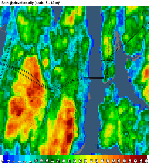
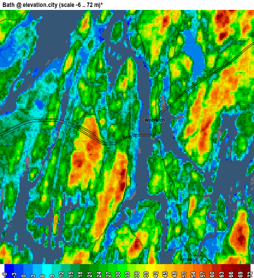
Below is the Elevation map of Bath, which displays elevation range with different colors. Scale of the first map is from -5 to 69 m (-16 to 226 ft) with average elevation of 24.1 meters (=79 ft) [note 1]
These maps also provides idea of topography and contour of this city, they are displayed at different zoom levels. More info about maps, scale and edge coordinates you can find below images.
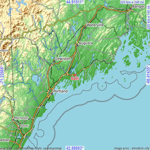
| \ | Map #1 | Map #2 | Topo.Map |
| Scale [m] | -5..69 m | -6..72 m | × |
| Scale [ft] | -16..226 ft | -20..236 ft | × |
| Average | 24.1 m = 79 ft | 22.9 m = 75 ft | × |
| Width | 7.04 km = 4.4 mi | 14.08 km = 8.7 mi | 225.3 km = 140 mi |
| Height | 7.04 km = 4.4 mi | 14.08 km = 8.7 mi | 225.3 km = 140 mi |
| ↑Max Latitude | 43.942291° | 43.973925° | 44.91511° |
| Latitude at center | 43.91064° | 43.91064° | 43.91064° |
| ↓Min Latitude | 43.878972° | 43.847288° | 42.88893° |
| ← Min Longitude | -69.864545° | -69.908491° | -71.22685° |
| Longitude center | -69.8206° | -69.8206° | -69.8206° |
| →Max Longitude | -69.776655° | -69.732709° | -68.41435° |
Nearby cities:
Cities around Bath sort by population:
• Brunswick elevation 21 m
11.6 km,  272°
272°
• North Bath 10 m
2.7 km,  8°
8°
• Topsham 47 m
12.6 km,  278°
278°
• Harpswell Center 42 m
17.9 km,  227°
227°
• Lisbon Falls 32 m
21.4 km,  296°
296°
• Boothbay 38 m
15.5 km,  104°
104°
• Woolwich 14 m
1.8 km,  60°
60°
• Phippsburg 20 m
10 km,  177°
177°
• Richmond 0 m
19.7 km, 5°
• Edgecomb 44 m
16.1 km,  70°
70°
• Wiscasset 17 m
16.1 km,  50°
50°
• Boothbay Harbor 16 m
16.7 km,  112°
112°
Multilingual:
 En español:
Bath elevación 24 m.
 En France:
Bath élévation 24 m.


Sources and notes:
- [note 1] Map square and city borders are not equal. Map elevation data is calculated only from area inside that square.
- [src 1] Elevation data from geonames database provided with same terms of usage.
- [src 2] The elevation map of Bath is generated using elevation data from NASA's 3 arcsec (90m) resolution SRTM data.
- [src 3] Base (background) map © OpenStreetMap contributors tiles are generated by Geofabrik and OpenTopoMap.
Copyright & License:
This Bath Elevation Map is licensed under CC BY-SA. You may reuse any part from this page, if you give a proper credit by linking to this URL:
 More info on terms of use page.