Northport elevation
Northport (Maine, Waldo County), United States elevation is 53 meters and Northport elevation in feet is 174 ft above sea level [src 1]. Northport is a populated place (feature code) with elevation that is 226 meters (741 ft) smaller than average city elevation in United States.
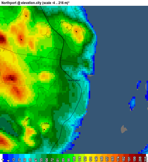
Below is the Elevation map of Northport, which displays elevation range with different colors. Scale of the first map is from -4 to 216 m (-13 to 709 ft) with average elevation of 88.8 meters (=291 ft) [note 1]
These maps also provides idea of topography and contour of this city, they are displayed at different zoom levels. More info about maps, scale and edge coordinates you can find below images.
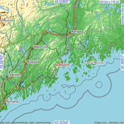
| \ | Map #1 | Topo.Map |
| Scale [m] | -4..216 m | × |
| Scale [ft] | -13..709 ft | × |
| Average | 88.8 m = 291 ft | × |
| Width | 6.99 km = 4.3 mi | 223.7 km = 139 mi |
| Height | 6.99 km = 4.3 mi | 223.7 km = 139 mi |
| ↑Max Latitude | 44.369283° | 45.33503° |
| Latitude at center | 44.33786° | 44.33786° |
| ↓Min Latitude | 44.306421° | 43.32344° |
| ← Min Longitude | -69.005365° | -70.36767° |
| Longitude center | -68.96142° | -68.96142° |
| →Max Longitude | -68.917475° | -67.55517° |
Nearby cities:
Cities around Northport sort by population:
• Belfast elevation 29 m
10.4 km,  339°
339°
• Camden 11 m
16.4 km,  210°
210°
• Rockport 19 m
19.3 km, 208°
• Lincolnville 7 m
7.3 km, 210°
• Deer Isle 13 m
25.9 km,  119°
119°
• Stockton Springs 38 m
18.8 km,  26°
26°
• Swanville 60 m
20.6 km,  351°
351°
• Penobscot 11 m
24.4 km,  54°
54°
• Hope 109 m
17.7 km,  242°
242°
• Appleton 51 m
23.7 km,  256°
256°
• Searsmont 68 m
18.8 km,  278°
278°
• Castine 22 m
14 km,  66°
66°
Multilingual:
 En español:
Northport elevación 53 m.
 En France:
Northport élévation 53 m.
 Auf Deutsch:
Northport höhe über dem Meeresspiegel ist 53 m.

Sources and notes:
- [note 1] Map square and city borders are not equal. Map elevation data is calculated only from area inside that square.
- [src 1] Elevation data from geonames database provided with same terms of usage.
- [src 2] The elevation map of Northport is generated using elevation data from NASA's 3 arcsec (90m) resolution SRTM data.
- [src 3] Base (background) map © OpenStreetMap contributors tiles are generated by Geofabrik and OpenTopoMap.
Copyright & License:
This Northport Elevation Map is licensed under CC BY-SA. You may reuse any part from this page, if you give a proper credit by linking to this URL:
 More info on terms of use page.