Belfast elevation
Belfast (Maine, Waldo County), United States elevation is 29 meters and Belfast elevation in feet is 95 ft above sea level [src 1]. Belfast is a seat of a second-order administrative division (feature code) with elevation that is 250 meters (820 ft) smaller than average city elevation in United States.
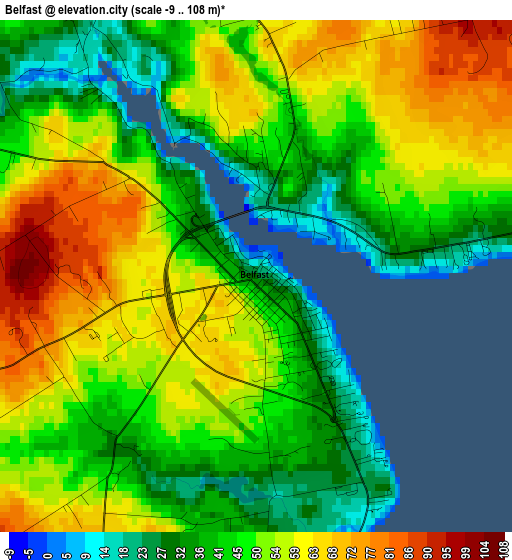
Below is the Elevation map of Belfast, which displays elevation range with different colors. Scale of the first map is from -9 to 108 m (-30 to 354 ft) with average elevation of 49 meters (=161 ft) [note 1]
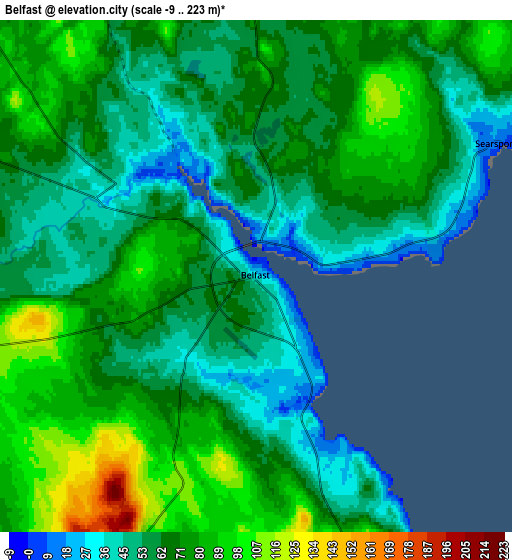
These maps also provides idea of topography and contour of this city, they are displayed at different zoom levels. More info about maps, scale and edge coordinates you can find below images.
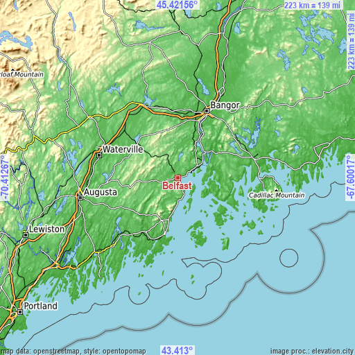
| \ | Map #1 | Map #2 | Topo.Map |
| Scale [m] | -9..108 m | -9..223 m | × |
| Scale [ft] | -30..354 ft | -30..732 ft | × |
| Average | 49 m = 161 ft | 67.6 m = 222 ft | × |
| Width | 6.98 km = 4.3 mi | 13.96 km = 8.7 mi | 223.3 km = 138.8 mi |
| Height | 6.98 km = 4.3 mi | 13.96 km = 8.7 mi | 223.3 km = 138.8 mi |
| ↑Max Latitude | 44.457285° | 44.488644° | 45.42156° |
| Latitude at center | 44.42591° | 44.42591° | 44.42591° |
| ↓Min Latitude | 44.394518° | 44.363109° | 43.413° |
| ← Min Longitude | -69.050365° | -69.094311° | -70.41267° |
| Longitude center | -69.00642° | -69.00642° | -69.00642° |
| →Max Longitude | -68.962475° | -68.918529° | -67.60017° |
Nearby cities:
Cities around Belfast sort by population:
• Camden elevation 11 m
24.5 km,  190°
190°
• Bucksport 16 m
23.4 km,  45°
45°
• Lincolnville 7 m
16.1 km,  180°
180°
• Stockton Springs 38 m
13.8 km,  59°
59°
• Swanville 60 m
10.6 km,  3°
3°
• Penobscot 11 m
23.8 km,  79°
79°
• Northport 53 m
10.4 km,  159°
159°
• Hope 109 m
21.6 km,  214°
214°
• Searsmont 68 m
16.6 km,  244°
244°
• Frankfort 13 m
22.9 km,  26°
26°
• Brooks 116 m
16.5 km,  326°
326°
• Castine 22 m
17 km,  104°
104°
Multilingual:
 En español:
Belfast elevación 29 m.
 En France:
Belfast élévation 29 m.


Sources and notes:
- [note 1] Map square and city borders are not equal. Map elevation data is calculated only from area inside that square.
- [src 1] Elevation data from geonames database provided with same terms of usage.
- [src 2] The elevation map of Belfast is generated using elevation data from NASA's 3 arcsec (90m) resolution SRTM data.
- [src 3] Base (background) map © OpenStreetMap contributors tiles are generated by Geofabrik and OpenTopoMap.
Copyright & License:
This Belfast Elevation Map is licensed under CC BY-SA. You may reuse any part from this page, if you give a proper credit by linking to this URL:
 More info on terms of use page.