Kingfield elevation
Kingfield (Maine, Franklin County), United States elevation is 170 meters and Kingfield elevation in feet is 558 ft above sea level [src 1]. Kingfield is a populated place (feature code) with elevation that is 109 meters (358 ft) smaller than average city elevation in United States.
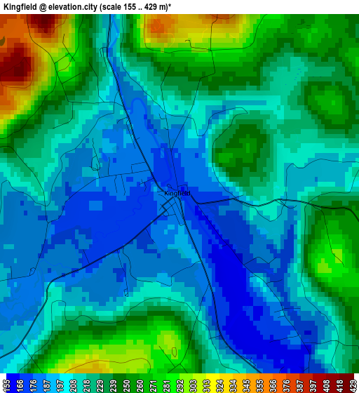
Below is the Elevation map of Kingfield, which displays elevation range with different colors. Scale of the first map is from 155 to 429 m (509 to 1407 ft) with average elevation of 221.3 meters (=726 ft) [note 1]
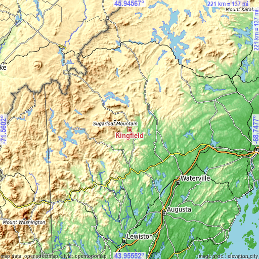
These maps also provides idea of topography and contour of this city, they are displayed at different zoom levels. More info about maps, scale and edge coordinates you can find below images.
| \ | Map #1 | Topo.Map |
| Scale [m] | 155..429 m | × |
| Scale [ft] | 509..1407 ft | × |
| Average | 221.3 m = 726 ft | × |
| Width | 6.92 km = 4.3 mi | 221.3 km = 137.5 mi |
| Height | 6.92 km = 4.3 mi | 221.3 km = 137.5 mi |
| ↑Max Latitude | 44.990308° | 45.94567° |
| Latitude at center | 44.95922° | 44.95922° |
| ↓Min Latitude | 44.928115° | 43.95552° |
| ← Min Longitude | -70.197895° | -71.5602° |
| Longitude center | -70.15395° | -70.15395° |
| →Max Longitude | -70.110005° | -68.7477° |
Nearby cities:
Cities around Kingfield sort by population:
• Skowhegan elevation 50 m
40.5 km,  122°
122°
• Jay 116 m
50.9 km,  185°
185°
• Farmington 127 m
32.1 km,  179°
179°
• Madison 91 m
28.1 km,  129°
129°
• Wilton 168 m
41.2 km, 188°
• Norridgewock 61 m
39.6 km, 133°
• New Sharon 114 m
37.2 km,  162°
162°
• Strong 153 m
17.7 km,  197°
197°
• Cornville 139 m
40.2 km,  109°
109°
• Chesterville 117 m
45.7 km,  173°
173°
• Phillips 175 m
21 km,  224°
224°
• Rome 99 m
47.3 km,  151°
151°
Multilingual:
 En español:
Kingfield elevación 170 m.
 En France:
Kingfield élévation 170 m.
 Auf Deutsch:
Kingfield höhe über dem Meeresspiegel ist 170 m.

Sources and notes:
- [note 1] Map square and city borders are not equal. Map elevation data is calculated only from area inside that square.
- [src 1] Elevation data from geonames database provided with same terms of usage.
- [src 2] The elevation map of Kingfield is generated using elevation data from NASA's 3 arcsec (90m) resolution SRTM data.
- [src 3] Base (background) map © OpenStreetMap contributors tiles are generated by Geofabrik and OpenTopoMap.
Copyright & License:
This Kingfield Elevation Map is licensed under CC BY-SA. You may reuse any part from this page, if you give a proper credit by linking to this URL:
 More info on terms of use page.