Westborough elevation
Westborough (Massachusetts, Worcester County), United States elevation is 96 meters and Westborough elevation in feet is 315 ft above sea level [src 1]. Westborough is a populated place (feature code) with elevation that is 183 meters (600 ft) smaller than average city elevation in United States.
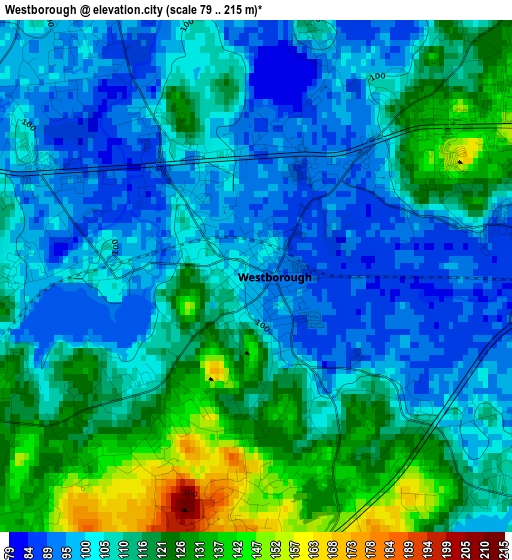
Below is the Elevation map of Westborough, which displays elevation range with different colors. Scale of the first map is from 79 to 215 m (259 to 705 ft) with average elevation of 110.3 meters (=362 ft) [note 1]
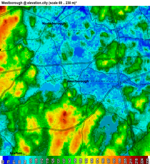
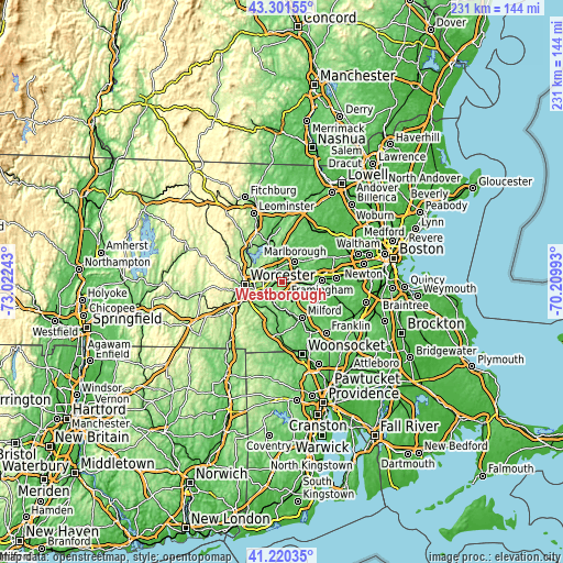
These maps also provides idea of topography and contour of this city, they are displayed at different zoom levels. More info about maps, scale and edge coordinates you can find below images.
| \ | Map #1 | Map #2 | Topo.Map |
| Scale [m] | 79..215 m | 69..230 m | × |
| Scale [ft] | 259..705 ft | 226..755 ft | × |
| Average | 110.3 m = 362 ft | 120.7 m = 396 ft | × |
| Width | 7.23 km = 4.5 mi | 14.46 km = 9 mi | 231.4 km = 143.8 mi |
| Height | 7.23 km = 4.5 mi | 14.46 km = 9 mi | 231.4 km = 143.8 mi |
| ↑Max Latitude | 42.302051° | 42.334545° | 43.30155° |
| Latitude at center | 42.26954° | 42.26954° | 42.26954° |
| ↓Min Latitude | 42.237013° | 42.204468° | 41.22035° |
| ← Min Longitude | -71.660125° | -71.704071° | -73.02243° |
| Longitude center | -71.61618° | -71.61618° | -71.61618° |
| →Max Longitude | -71.572235° | -71.528289° | -70.20993° |
Nearby cities:
Cities around Westborough sort by population:
• Marlborough elevation 127 m
10 km,  31°
31°
• Shrewsbury 199 m
8.5 km,  290°
290°
• Grafton 149 m
9 km,  219°
219°
• Ashland 60 m
12.6 km,  94°
94°
• Southborough 94 m
8.5 km,  61°
61°
• Hamilton Worcester 153 m
12.5 km,  263°
263°
• Northborough 93 m
5.9 km,  339°
339°
• Sunderland 157 m
13.1 km, 257°
• Upton 92 m
10.6 km,  173°
173°
• Cordaville 86 m
7.6 km, 90°
• Hopkinton 135 m
8.9 km,  120°
120°
• Berlin 99 m
12.5 km,  352°
352°
Multilingual:
 En español:
Westborough elevación 96 m.
 En France:
Westborough élévation 96 m.
 Auf Deutsch:
Westborough höhe über dem Meeresspiegel ist 96 m.

Sources and notes:
- [note 1] Map square and city borders are not equal. Map elevation data is calculated only from area inside that square.
- [src 1] Elevation data from geonames database provided with same terms of usage.
- [src 2] The elevation map of Westborough is generated using elevation data from NASA's 3 arcsec (90m) resolution SRTM data.
- [src 3] Base (background) map © OpenStreetMap contributors tiles are generated by Geofabrik and OpenTopoMap.
Copyright & License:
This Westborough Elevation Map is licensed under CC BY-SA. You may reuse any part from this page, if you give a proper credit by linking to this URL:
 More info on terms of use page.