Sterling elevation
Sterling (Massachusetts, Worcester County), United States elevation is 157 meters and Sterling elevation in feet is 515 ft above sea level [src 1]. Sterling is a populated place (feature code) with elevation that is 122 meters (400 ft) smaller than average city elevation in United States.
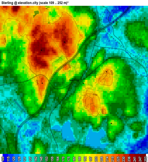
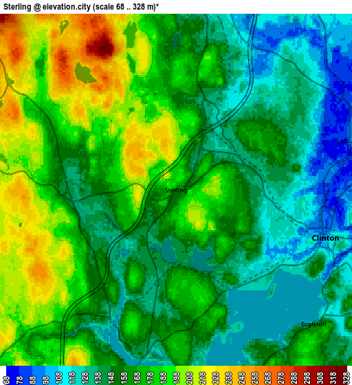
Below is the Elevation map of Sterling, which displays elevation range with different colors. Scale of the first map is from 109 to 252 m (358 to 827 ft) with average elevation of 167.1 meters (=548 ft) [note 1]
These maps also provides idea of topography and contour of this city, they are displayed at different zoom levels. More info about maps, scale and edge coordinates you can find below images.
| \ | Map #1 | Map #2 | Topo.Map |
| Scale [m] | 109..252 m | 68..328 m | × |
| Scale [ft] | 358..827 ft | 223..1076 ft | × |
| Average | 167.1 m = 548 ft | 163.1 m = 535 ft | × |
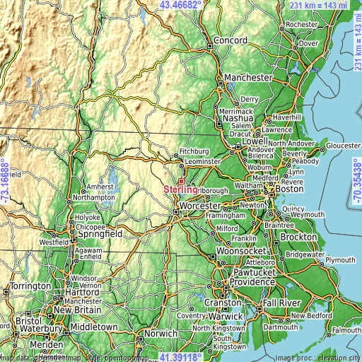
| Width | 7.21 km = 4.5 mi | 14.42 km = 9 mi | 230.8 km = 143.4 mi |
| Height | 7.21 km = 4.5 mi | 14.42 km = 9 mi | 230.8 km = 143.4 mi |
| ↑Max Latitude | 42.470014° | 42.502421° | 43.46682° |
| Latitude at center | 42.43759° | 42.43759° | 42.43759° |
| ↓Min Latitude | 42.405149° | 42.372692° | 41.39118° |
| ← Min Longitude | -71.804575° | -71.848521° | -73.16688° |
| Longitude center | -71.76063° | -71.76063° | -71.76063° |
| →Max Longitude | -71.716685° | -71.672739° | -70.35438° |
Nearby cities:
Cities around Sterling sort by population:
• Leominster elevation 124 m
9.7 km,  0°
0°
• Holden 253 m
12.7 km,  221°
221°
• West Boylston 168 m
8.1 km,  194°
194°
• Lancaster 99 m
7.5 km,  74°
74°
• Clinton 118 m
6.8 km,  109°
109°
• Harvard 129 m
16.2 km,  64°
64°
• Bolton 123 m
12.5 km,  92°
92°
• Boylston 120 m
6.9 km,  137°
137°
• Princeton 347 m
9.7 km,  277°
277°
• Berlin 99 m
11.9 km,  121°
121°
• South Lancaster 91 m
6.1 km,  82°
82°
• Shirley 89 m
14.9 km,  37°
37°
Multilingual:
 En español:
Sterling elevación 157 m.
 En France:
Sterling élévation 157 m.
 Auf Deutsch:
Sterling höhe über dem Meeresspiegel ist 157 m.

Sources and notes:
- [note 1] Map square and city borders are not equal. Map elevation data is calculated only from area inside that square.
- [src 1] Elevation data from geonames database provided with same terms of usage.
- [src 2] The elevation map of Sterling is generated using elevation data from NASA's 3 arcsec (90m) resolution SRTM data.
- [src 3] Base (background) map © OpenStreetMap contributors tiles are generated by Geofabrik and OpenTopoMap.
Copyright & License:
This Sterling Elevation Map is licensed under CC BY-SA. You may reuse any part from this page, if you give a proper credit by linking to this URL:
 More info on terms of use page.