Natick elevation
Natick (Massachusetts, Middlesex County), United States elevation is 55 meters and Natick elevation in feet is 180 ft above sea level [src 1]. Natick is a populated place (feature code) with elevation that is 224 meters (735 ft) smaller than average city elevation in United States.
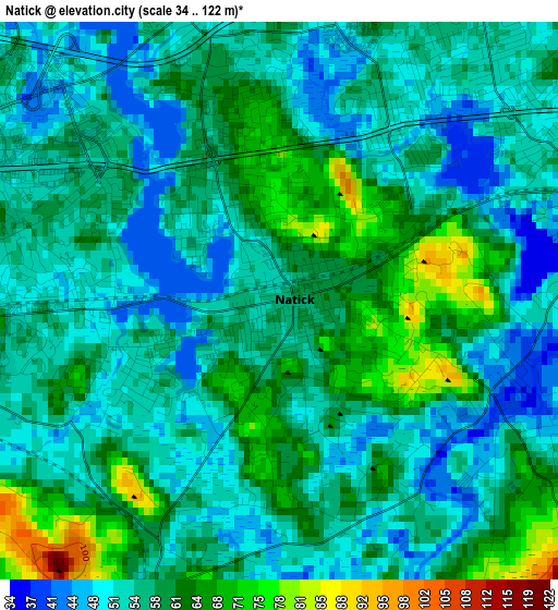
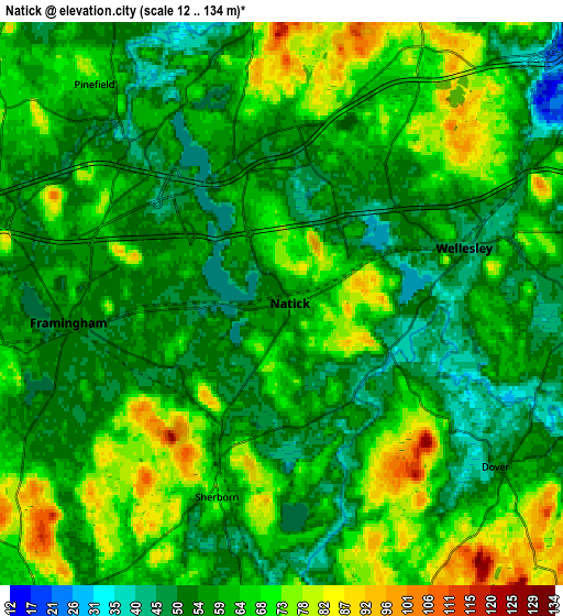
Below is the Elevation map of Natick, which displays elevation range with different colors. Scale of the first map is from 34 to 122 m (112 to 400 ft) with average elevation of 57 meters (=187 ft) [note 1]
These maps also provides idea of topography and contour of this city, they are displayed at different zoom levels. More info about maps, scale and edge coordinates you can find below images.
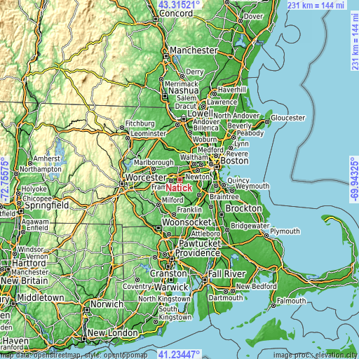
| \ | Map #1 | Map #2 | Topo.Map |
| Scale [m] | 34..122 m | 12..134 m | × |
| Scale [ft] | 112..400 ft | 39..440 ft | × |
| Average | 57 m = 187 ft | 61.3 m = 201 ft | × |
| Width | 7.23 km = 4.5 mi | 14.46 km = 9 mi | 231.4 km = 143.8 mi |
| Height | 7.23 km = 4.5 mi | 14.46 km = 9 mi | 231.3 km = 143.7 mi |
| ↑Max Latitude | 42.315933° | 42.34842° | 43.31521° |
| Latitude at center | 42.28343° | 42.28343° | 42.28343° |
| ↓Min Latitude | 42.25091° | 42.218373° | 41.23447° |
| ← Min Longitude | -71.393445° | -71.437391° | -72.75575° |
| Longitude center | -71.3495° | -71.3495° | -71.3495° |
| →Max Longitude | -71.305555° | -71.261609° | -69.94325° |
Nearby cities:
Cities around Natick sort by population:
• Framingham elevation 54 m
5.5 km,  265°
265°
• Framingham Center 84 m
7.4 km,  282°
282°
• Needham 58 m
9.6 km,  90°
90°
• Wellesley 44 m
4.9 km,  72°
72°
• Ashland 60 m
9.7 km,  255°
255°
• Holliston 62 m
11.1 km,  213°
213°
• Wayland 38 m
8.9 km,  353°
353°
• Weston 60 m
10 km,  22°
22°
• Cochituate 55 m
4.3 km,  343°
343°
• Medfield 57 m
11.2 km,  161°
161°
• Sherborn 70 m
5.2 km,  198°
198°
• Dover 56 m
6.9 km,  127°
127°
Multilingual:
 En español:
Natick elevación 55 m.
 En France:
Natick élévation 55 m.


Sources and notes:
- [note 1] Map square and city borders are not equal. Map elevation data is calculated only from area inside that square.
- [src 1] Elevation data from geonames database provided with same terms of usage.
- [src 2] The elevation map of Natick is generated using elevation data from NASA's 3 arcsec (90m) resolution SRTM data.
- [src 3] Base (background) map © OpenStreetMap contributors tiles are generated by Geofabrik and OpenTopoMap.
Copyright & License:
This Natick Elevation Map is licensed under CC BY-SA. You may reuse any part from this page, if you give a proper credit by linking to this URL:
 More info on terms of use page.