Maynard elevation
Maynard (Massachusetts, Middlesex County), United States elevation is 50 meters and Maynard elevation in feet is 164 ft above sea level [src 1]. Maynard is a populated place (feature code) with elevation that is 229 meters (751 ft) smaller than average city elevation in United States.
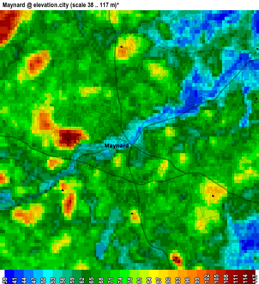
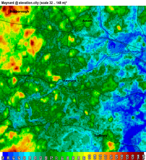
Below is the Elevation map of Maynard, which displays elevation range with different colors. Scale of the first map is from 38 to 117 m (125 to 384 ft) with average elevation of 67.5 meters (=221 ft) [note 1]
These maps also provides idea of topography and contour of this city, they are displayed at different zoom levels. More info about maps, scale and edge coordinates you can find below images.
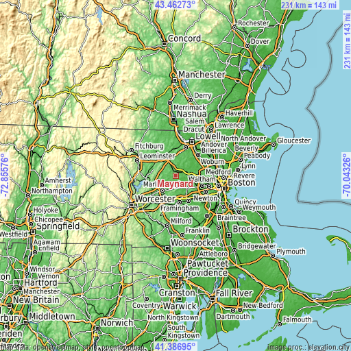
| \ | Map #1 | Map #2 | Topo.Map |
| Scale [m] | 38..117 m | 32..148 m | × |
| Scale [ft] | 125..384 ft | 105..486 ft | × |
| Average | 67.5 m = 221 ft | 68.6 m = 225 ft | × |
| Width | 7.21 km = 4.5 mi | 14.43 km = 9 mi | 230.8 km = 143.4 mi |
| Height | 7.21 km = 4.5 mi | 14.43 km = 9 mi | 230.8 km = 143.4 mi |
| ↑Max Latitude | 42.465856° | 42.498265° | 43.46273° |
| Latitude at center | 42.43343° | 42.43343° | 42.43343° |
| ↓Min Latitude | 42.400987° | 42.368528° | 41.38695° |
| ← Min Longitude | -71.493455° | -71.537401° | -72.85576° |
| Longitude center | -71.44951° | -71.44951° | -71.44951° |
| →Max Longitude | -71.405565° | -71.361619° | -70.04326° |
Nearby cities:
Cities around Maynard sort by population:
• Marlborough elevation 127 m
12.9 km,  220°
220°
• Acton 86 m
5.9 km,  13°
13°
• Sudbury 64 m
6.2 km,  153°
153°
• Concord 41 m
8.8 km,  70°
70°
• Hudson 67 m
10.6 km,  244°
244°
• Wayland 38 m
10.7 km,  137°
137°
• Lincoln 78 m
12 km,  93°
93°
• West Concord 41 m
5.2 km,  57°
57°
• Stow 72 m
4.6 km,  274°
274°
• Boxborough 102 m
9.1 km,  314°
314°
• Bolton 123 m
13 km, 270°
• Littleton Common 87 m
12.7 km,  350°
350°
Multilingual:
 En español:
Maynard elevación 50 m.
 En France:
Maynard élévation 50 m.


Sources and notes:
- [note 1] Map square and city borders are not equal. Map elevation data is calculated only from area inside that square.
- [src 1] Elevation data from geonames database provided with same terms of usage.
- [src 2] The elevation map of Maynard is generated using elevation data from NASA's 3 arcsec (90m) resolution SRTM data.
- [src 3] Base (background) map © OpenStreetMap contributors tiles are generated by Geofabrik and OpenTopoMap.
Copyright & License:
This Maynard Elevation Map is licensed under CC BY-SA. You may reuse any part from this page, if you give a proper credit by linking to this URL:
 More info on terms of use page.