Kingston elevation
Kingston (Massachusetts, Plymouth County), United States elevation is 16 meters and Kingston elevation in feet is 52 ft above sea level [src 1]. Kingston is a populated place (feature code) with elevation that is 263 meters (863 ft) smaller than average city elevation in United States.
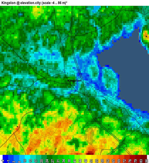
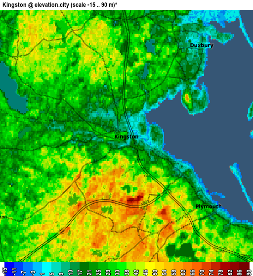
Below is the Elevation map of Kingston, which displays elevation range with different colors. Scale of the first map is from -4 to 86 m (-13 to 282 ft) with average elevation of 29.4 meters (=96 ft) [note 1]
These maps also provides idea of topography and contour of this city, they are displayed at different zoom levels. More info about maps, scale and edge coordinates you can find below images.
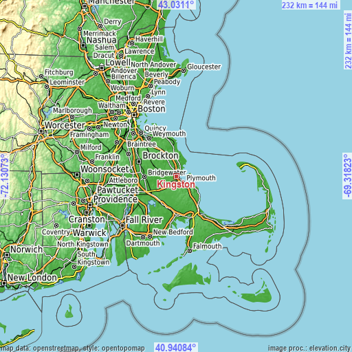
| \ | Map #1 | Map #2 | Topo.Map |
| Scale [m] | -4..86 m | -15..90 m | × |
| Scale [ft] | -13..282 ft | -49..295 ft | × |
| Average | 29.4 m = 96 ft | 33 m = 108 ft | × |
| Width | 7.26 km = 4.5 mi | 14.53 km = 9 mi | 232.4 km = 144.4 mi |
| Height | 7.26 km = 4.5 mi | 14.53 km = 9 mi | 232.4 km = 144.4 mi |
| ↑Max Latitude | 42.027202° | 42.059838° | 43.0311° |
| Latitude at center | 41.99455° | 41.99455° | 41.99455° |
| ↓Min Latitude | 41.961881° | 41.929195° | 40.94084° |
| ← Min Longitude | -70.768425° | -70.812371° | -72.13073° |
| Longitude center | -70.72448° | -70.72448° | -70.72448° |
| →Max Longitude | -70.680535° | -70.636589° | -69.31823° |
Nearby cities:
Cities around Kingston sort by population:
• Hanover elevation 20 m
15 km,  331°
331°
• Carver 35 m
12.7 km,  194°
194°
• Halifax 31 m
11.4 km,  268°
268°
• Plymouth 19 m
6.2 km,  130°
130°
• Ocean Bluff-Brant Rock 1 m
13.2 km,  24°
24°
• Marshfield 4 m
10.9 km,  8°
8°
• North Plymouth 24 m
4.3 km, 127°
• South Duxbury 17 m
4.7 km,  47°
47°
• North Pembroke 25 m
12.3 km, 332°
• Plympton 36 m
8.8 km,  238°
238°
• Green Harbor-Cedar Crest 16 m
10.5 km,  31°
31°
• Duxbury 9 m
6.8 km,  39°
39°
Multilingual:
 En español:
Kingston elevación 16 m.
 En France:
Kingston élévation 16 m.


Sources and notes:
- [note 1] Map square and city borders are not equal. Map elevation data is calculated only from area inside that square.
- [src 1] Elevation data from geonames database provided with same terms of usage.
- [src 2] The elevation map of Kingston is generated using elevation data from NASA's 3 arcsec (90m) resolution SRTM data.
- [src 3] Base (background) map © OpenStreetMap contributors tiles are generated by Geofabrik and OpenTopoMap.
Copyright & License:
This Kingston Elevation Map is licensed under CC BY-SA. You may reuse any part from this page, if you give a proper credit by linking to this URL:
 More info on terms of use page.