Chelmsford elevation
Chelmsford (Massachusetts, Middlesex County), United States elevation is 88 meters and Chelmsford elevation in feet is 289 ft above sea level [src 1]. Chelmsford is a populated place (feature code) with elevation that is 191 meters (627 ft) smaller than average city elevation in United States.
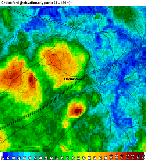
Below is the Elevation map of Chelmsford, which displays elevation range with different colors. Scale of the first map is from 31 to 124 m (102 to 407 ft) with average elevation of 60.5 meters (=198 ft) [note 1]
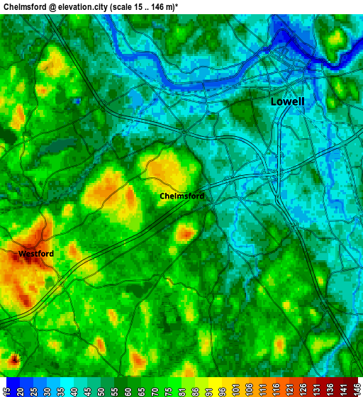
These maps also provides idea of topography and contour of this city, they are displayed at different zoom levels. More info about maps, scale and edge coordinates you can find below images.
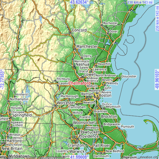
| \ | Map #1 | Map #2 | Topo.Map |
| Scale [m] | 31..124 m | 15..146 m | × |
| Scale [ft] | 102..407 ft | 49..479 ft | × |
| Average | 60.5 m = 198 ft | 60.1 m = 197 ft | × |
| Width | 7.19 km = 4.5 mi | 14.39 km = 8.9 mi | 230.2 km = 143 mi |
| Height | 7.19 km = 4.5 mi | 14.39 km = 8.9 mi | 230.2 km = 143 mi |
| ↑Max Latitude | 42.63215° | 42.664473° | 43.62634° |
| Latitude at center | 42.59981° | 42.59981° | 42.59981° |
| ↓Min Latitude | 42.567453° | 42.53508° | 41.55608° |
| ← Min Longitude | -71.411225° | -71.455171° | -72.77353° |
| Longitude center | -71.36728° | -71.36728° | -71.36728° |
| →Max Longitude | -71.323335° | -71.279389° | -69.96103° |
Nearby cities:
Cities around Chelmsford sort by population:
• Lowell elevation 39 m
5.6 km,  48°
48°
• Billerica 79 m
9.3 km,  119°
119°
• Tewksbury 40 m
11 km,  83°
83°
• Dracut 51 m
9.5 km,  34°
34°
• Westford 125 m
6.2 km,  248°
248°
• Acton 86 m
13.8 km,  202°
202°
• Bedford 45 m
14.2 km,  148°
148°
• Tyngsboro 46 m
9.8 km,  331°
331°
• Pinehurst 35 m
13.8 km, 124°
• Carlisle 68 m
8 km,  169°
169°
• Dunstable 72 m
12.6 km,  311°
311°
• Littleton Common 87 m
10.6 km,  235°
235°
Multilingual:
 En español:
Chelmsford elevación 88 m.
 En France:
Chelmsford élévation 88 m.
 Auf Deutsch:
Chelmsford höhe über dem Meeresspiegel ist 88 m.

Sources and notes:
- [note 1] Map square and city borders are not equal. Map elevation data is calculated only from area inside that square.
- [src 1] Elevation data from geonames database provided with same terms of usage.
- [src 2] The elevation map of Chelmsford is generated using elevation data from NASA's 3 arcsec (90m) resolution SRTM data.
- [src 3] Base (background) map © OpenStreetMap contributors tiles are generated by Geofabrik and OpenTopoMap.
Copyright & License:
This Chelmsford Elevation Map is licensed under CC BY-SA. You may reuse any part from this page, if you give a proper credit by linking to this URL:
 More info on terms of use page.