Athol elevation
Athol (Massachusetts, Worcester County), United States elevation is 170 meters and Athol elevation in feet is 558 ft above sea level [src 1]. Athol is a populated place (feature code) with elevation that is 109 meters (358 ft) smaller than average city elevation in United States.
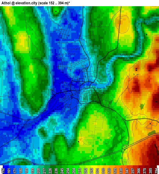
Below is the Elevation map of Athol, which displays elevation range with different colors. Scale of the first map is from 152 to 394 m (499 to 1293 ft) with average elevation of 237.5 meters (=779 ft) [note 1]
These maps also provides idea of topography and contour of this city, they are displayed at different zoom levels. More info about maps, scale and edge coordinates you can find below images.
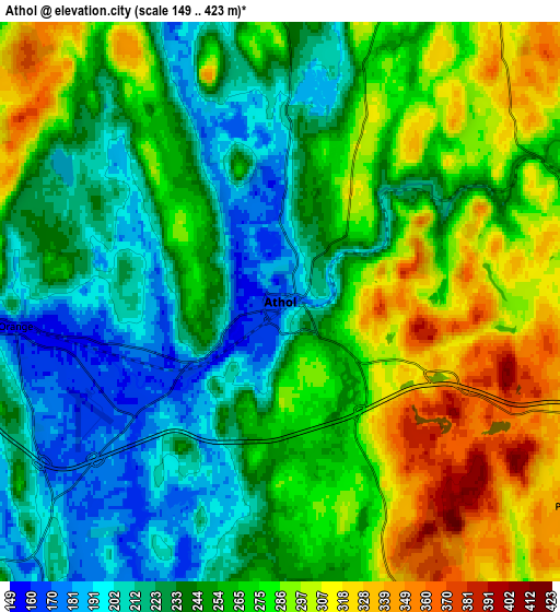
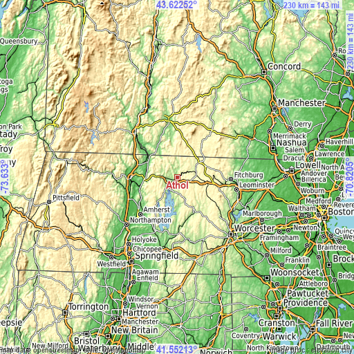
| \ | Map #1 | Map #2 | Topo.Map |
| Scale [m] | 152..394 m | 149..423 m | × |
| Scale [ft] | 499..1293 ft | 489..1388 ft | × |
| Average | 237.5 m = 779 ft | 256.9 m = 843 ft | × |
| Width | 7.19 km = 4.5 mi | 14.39 km = 8.9 mi | 230.2 km = 143 mi |
| Height | 7.19 km = 4.5 mi | 14.39 km = 8.9 mi | 230.2 km = 143 mi |
| ↑Max Latitude | 42.628262° | 42.660587° | 43.62252° |
| Latitude at center | 42.59592° | 42.59592° | 42.59592° |
| ↓Min Latitude | 42.563561° | 42.531186° | 41.55213° |
| ← Min Longitude | -72.270695° | -72.314641° | -73.633° |
| Longitude center | -72.22675° | -72.22675° | -72.22675° |
| →Max Longitude | -72.182805° | -72.138859° | -70.8205° |
Nearby cities:
Cities around Athol sort by population:
• Gardner elevation 325 m
18.9 km,  97°
97°
• Templeton 349 m
13.8 km,  108°
108°
• Winchendon 302 m
18 km,  56°
56°
• Orange 158 m
6.8 km,  264°
264°
• Baldwinville 273 m
12.4 km,  83°
83°
• Shutesbury 380 m
21.6 km,  224°
224°
• Phillipston 358 m
9.3 km,  124°
124°
• Erving 150 m
14 km,  271°
271°
• Royalston 309 m
9.6 km,  19°
19°
• Richmond 327 m
18 km,  348°
348°
• Northfield 91 m
21.6 km,  301°
301°
• Wendell 357 m
14.9 km,  249°
249°
Multilingual:
 En español:
Athol elevación 170 m.
 En France:
Athol élévation 170 m.


Sources and notes:
- [note 1] Map square and city borders are not equal. Map elevation data is calculated only from area inside that square.
- [src 1] Elevation data from geonames database provided with same terms of usage.
- [src 2] The elevation map of Athol is generated using elevation data from NASA's 3 arcsec (90m) resolution SRTM data.
- [src 3] Base (background) map © OpenStreetMap contributors tiles are generated by Geofabrik and OpenTopoMap.
Copyright & License:
This Athol Elevation Map is licensed under CC BY-SA. You may reuse any part from this page, if you give a proper credit by linking to this URL:
 More info on terms of use page.