Pierceton elevation
Pierceton (Indiana, Kosciusko County), United States elevation is 281 meters and Pierceton elevation in feet is 922 ft above sea level [src 1]. Pierceton is a populated place (feature code) with elevation that is 2 meters (7 ft) bigger than average city elevation in United States.
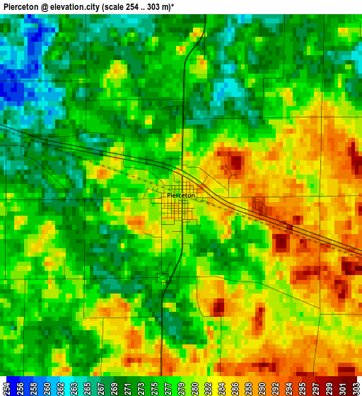
Below is the Elevation map of Pierceton, which displays elevation range with different colors. Scale of the first map is from 254 to 303 m (833 to 994 ft) with average elevation of 277.6 meters (=911 ft) [note 1]
These maps also provides idea of topography and contour of this city, they are displayed at different zoom levels. More info about maps, scale and edge coordinates you can find below images.
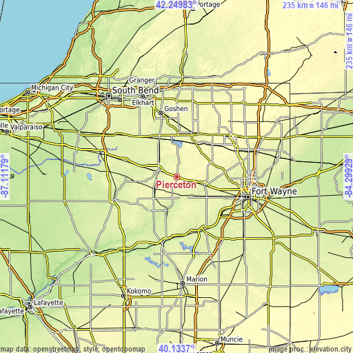
| \ | Map #1 | Topo.Map |
| Scale [m] | 254..303 m | × |
| Scale [ft] | 833..994 ft | × |
| Average | 277.6 m = 911 ft | × |
| Width | 7.35 km = 4.6 mi | 235.3 km = 146.2 mi |
| Height | 7.35 km = 4.6 mi | 235.3 km = 146.2 mi |
| ↑Max Latitude | 41.233377° | 42.24983° |
| Latitude at center | 41.20032° | 41.20032° |
| ↓Min Latitude | 41.167247° | 40.1337° |
| ← Min Longitude | -85.749485° | -87.11179° |
| Longitude center | -85.70554° | -85.70554° |
| →Max Longitude | -85.661595° | -84.29929° |
Nearby cities:
Cities around Pierceton sort by population:
• Warsaw elevation 251 m
13 km,  288°
288°
• Columbia City 263 m
18.8 km,  104°
104°
• North Manchester 240 m
22.8 km,  193°
193°
• Winona Lake 253 m
10.2 km, 287°
• Ligonier 265 m
31.1 km,  18°
18°
• Syracuse 267 m
25.6 km,  351°
351°
• Albion 293 m
32 km,  47°
47°
• Churubusco 273 m
32.5 km,  84°
84°
• South Whitley 246 m
14.4 km,  153°
153°
• Milford 255 m
26.1 km,  333°
333°
• Tri-Lakes 286 m
22.6 km, 77°
• North Webster 269 m
13.9 km,  2°
2°
Multilingual:
 En español:
Pierceton elevación 281 m.
 En France:
Pierceton élévation 281 m.
 Auf Deutsch:
Pierceton höhe über dem Meeresspiegel ist 281 m.

Sources and notes:
- [note 1] Map square and city borders are not equal. Map elevation data is calculated only from area inside that square.
- [src 1] Elevation data from geonames database provided with same terms of usage.
- [src 2] The elevation map of Pierceton is generated using elevation data from NASA's 3 arcsec (90m) resolution SRTM data.
- [src 3] Base (background) map © OpenStreetMap contributors tiles are generated by Geofabrik and OpenTopoMap.
Copyright & License:
This Pierceton Elevation Map is licensed under CC BY-SA. You may reuse any part from this page, if you give a proper credit by linking to this URL:
 More info on terms of use page.