Ligonier elevation
Ligonier (Indiana, Noble County), United States elevation is 265 meters and Ligonier elevation in feet is 869 ft above sea level [src 1]. Ligonier is a populated place (feature code) with elevation that is 14 meters (46 ft) smaller than average city elevation in United States.
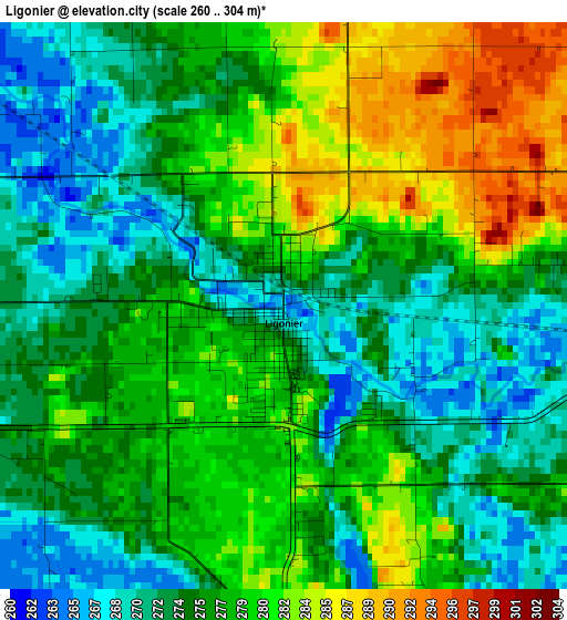
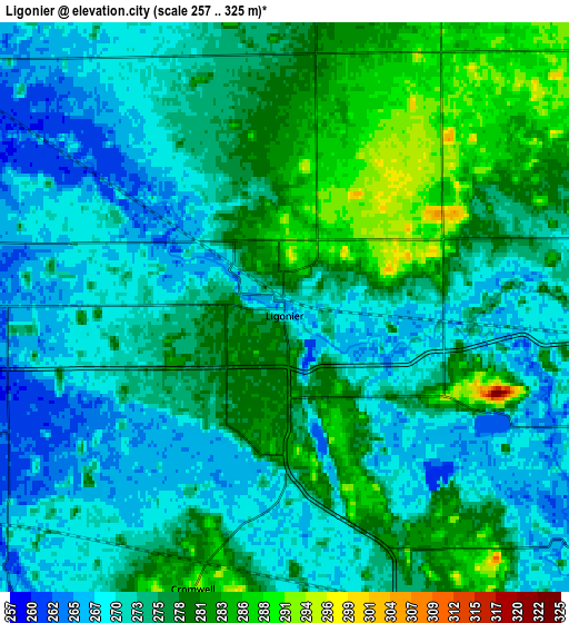
Below is the Elevation map of Ligonier, which displays elevation range with different colors. Scale of the first map is from 260 to 304 m (853 to 997 ft) with average elevation of 276.5 meters (=907 ft) [note 1]
These maps also provides idea of topography and contour of this city, they are displayed at different zoom levels. More info about maps, scale and edge coordinates you can find below images.
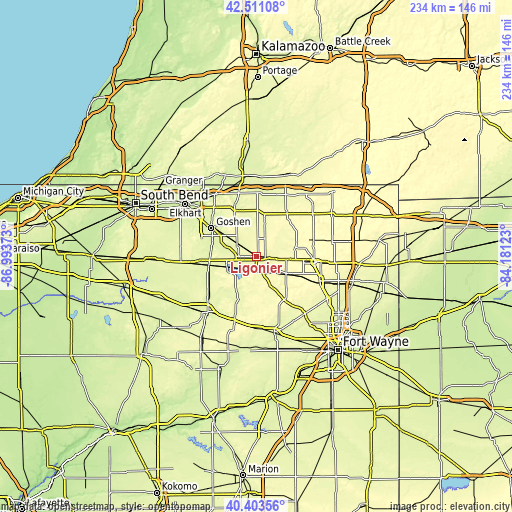
| \ | Map #1 | Map #2 | Topo.Map |
| Scale [m] | 260..304 m | 257..325 m | × |
| Scale [ft] | 853..997 ft | 843..1066 ft | × |
| Average | 276.5 m = 907 ft | 274.5 m = 901 ft | × |
| Width | 7.32 km = 4.5 mi | 14.65 km = 9.1 mi | 234.3 km = 145.6 mi |
| Height | 7.32 km = 4.5 mi | 14.65 km = 9.1 mi | 234.3 km = 145.6 mi |
| ↑Max Latitude | 41.498802° | 41.531707° | 42.51108° |
| Latitude at center | 41.46588° | 41.46588° | 41.46588° |
| ↓Min Latitude | 41.432941° | 41.399986° | 40.40356° |
| ← Min Longitude | -85.631425° | -85.675371° | -86.99373° |
| Longitude center | -85.58748° | -85.58748° | -85.58748° |
| →Max Longitude | -85.543535° | -85.499589° | -84.18123° |
Nearby cities:
Cities around Ligonier sort by population:
• Goshen elevation 242 m
24.3 km,  302°
302°
• Kendallville 302 m
27 km,  95°
95°
• Middlebury 253 m
25.3 km,  337°
337°
• Syracuse 267 m
14.4 km,  252°
252°
• Lagrange 285 m
24.2 km,  36°
36°
• Albion 293 m
15.7 km,  119°
119°
• Milford 255 m
22.4 km, 253°
• New Paris 250 m
20.4 km,  280°
280°
• Rome City 283 m
17.9 km,  79°
79°
• Topeka 281 m
9.1 km,  26°
26°
• North Webster 269 m
18.1 km,  210°
210°
• Wolcottville 284 m
19.6 km,  70°
70°
Multilingual:
 En español:
Ligonier elevación 265 m.
 En France:
Ligonier élévation 265 m.
 Auf Deutsch:
Ligonier höhe über dem Meeresspiegel ist 265 m.

Sources and notes:
- [note 1] Map square and city borders are not equal. Map elevation data is calculated only from area inside that square.
- [src 1] Elevation data from geonames database provided with same terms of usage.
- [src 2] The elevation map of Ligonier is generated using elevation data from NASA's 3 arcsec (90m) resolution SRTM data.
- [src 3] Base (background) map © OpenStreetMap contributors tiles are generated by Geofabrik and OpenTopoMap.
Copyright & License:
This Ligonier Elevation Map is licensed under CC BY-SA. You may reuse any part from this page, if you give a proper credit by linking to this URL:
 More info on terms of use page.