Lagrange elevation
Lagrange (Indiana, LaGrange County), United States elevation is 285 meters and Lagrange elevation in feet is 935 ft above sea level [src 1]. Lagrange is a seat of a second-order administrative division (feature code) with elevation that is 6 meters (20 ft) bigger than average city elevation in United States.
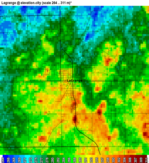
Below is the Elevation map of Lagrange, which displays elevation range with different colors. Scale of the first map is from 264 to 311 m (866 to 1020 ft) with average elevation of 283.8 meters (=931 ft) [note 1]
These maps also provides idea of topography and contour of this city, they are displayed at different zoom levels. More info about maps, scale and edge coordinates you can find below images.
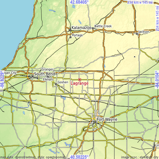
| \ | Map #1 | Topo.Map |
| Scale [m] | 264..311 m | × |
| Scale [ft] | 866..1020 ft | × |
| Average | 283.8 m = 931 ft | × |
| Width | 7.3 km = 4.5 mi | 233.7 km = 145.2 mi |
| Height | 7.3 km = 4.5 mi | 233.7 km = 145.2 mi |
| ↑Max Latitude | 41.674553° | 42.68405° |
| Latitude at center | 41.64172° | 41.64172° |
| ↓Min Latitude | 41.608871° | 40.58225° |
| ← Min Longitude | -85.460595° | -86.8229° |
| Longitude center | -85.41665° | -85.41665° |
| →Max Longitude | -85.372705° | -84.0104° |
Nearby cities:
Cities around Lagrange sort by population:
• Sturgis elevation 282 m
17.5 km,  359°
359°
• Kendallville 302 m
25.6 km,  150°
150°
• Ligonier 265 m
24.2 km,  216°
216°
• Middlebury 253 m
24.3 km,  278°
278°
• Bronson 281 m
31.6 km,  35°
35°
• Albion 293 m
27.4 km,  181°
181°
• Constantine 242 m
30.5 km,  316°
316°
• White Pigeon 250 m
25.6 km,  312°
312°
• Centreville 253 m
32.7 km,  343°
343°
• Rome City 283 m
16.5 km,  168°
168°
• Topeka 281 m
15.3 km, 221°
• Wolcottville 284 m
13.5 km,  162°
162°
Multilingual:
 En español:
Lagrange elevación 285 m.
 En France:
Lagrange élévation 285 m.
 Auf Deutsch:
Lagrange höhe über dem Meeresspiegel ist 285 m.

Sources and notes:
- [note 1] Map square and city borders are not equal. Map elevation data is calculated only from area inside that square.
- [src 1] Elevation data from geonames database provided with same terms of usage.
- [src 2] The elevation map of Lagrange is generated using elevation data from NASA's 3 arcsec (90m) resolution SRTM data.
- [src 3] Base (background) map © OpenStreetMap contributors tiles are generated by Geofabrik and OpenTopoMap.
Copyright & License:
This Lagrange Elevation Map is licensed under CC BY-SA. You may reuse any part from this page, if you give a proper credit by linking to this URL:
 More info on terms of use page.