Muncie elevation
Muncie (Indiana, Delaware County), United States elevation is 292 meters and Muncie elevation in feet is 958 ft above sea level [src 1]. Muncie is a seat of a second-order administrative division (feature code) with elevation that is 13 meters (43 ft) bigger than average city elevation in United States.
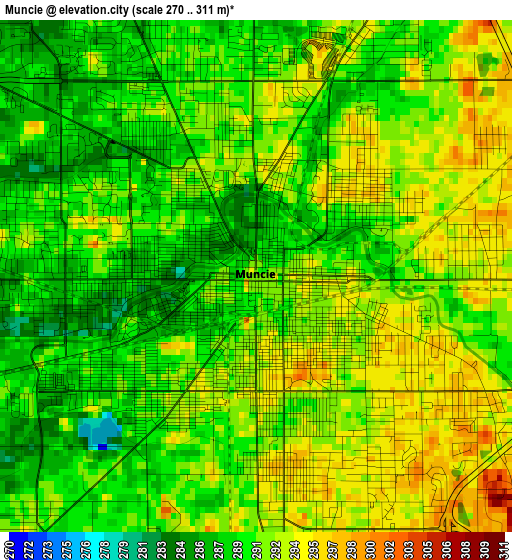
Below is the Elevation map of Muncie, which displays elevation range with different colors. Scale of the first map is from 270 to 311 m (886 to 1020 ft) with average elevation of 290.9 meters (=954 ft) [note 1]
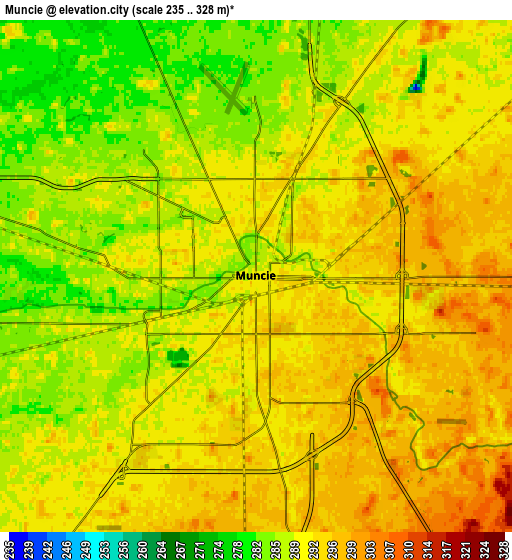
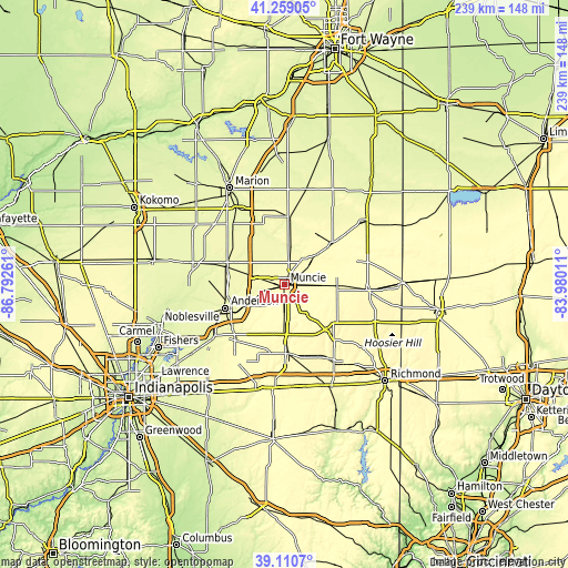
These maps also provides idea of topography and contour of this city, they are displayed at different zoom levels. More info about maps, scale and edge coordinates you can find below images.
| \ | Map #1 | Map #2 | Topo.Map |
| Scale [m] | 270..311 m | 235..328 m | × |
| Scale [ft] | 886..1020 ft | 771..1076 ft | × |
| Average | 290.9 m = 954 ft | 290.6 m = 953 ft | × |
| Width | 7.46 km = 4.6 mi | 14.93 km = 9.3 mi | 238.9 km = 148.4 mi |
| Height | 7.46 km = 4.6 mi | 14.93 km = 9.3 mi | 238.9 km = 148.4 mi |
| ↑Max Latitude | 40.22694° | 40.260484° | 41.25905° |
| Latitude at center | 40.19338° | 40.19338° | 40.19338° |
| ↓Min Latitude | 40.159803° | 40.12621° | 39.1107° |
| ← Min Longitude | -85.430305° | -85.474251° | -86.79261° |
| Longitude center | -85.38636° | -85.38636° | -85.38636° |
| →Max Longitude | -85.342415° | -85.298469° | -83.98011° |
Nearby cities:
Cities around Muncie sort by population:
• Anderson elevation 275 m
26.8 km,  248°
248°
• Yorktown 282 m
9.4 km,  256°
256°
• Alexandria 266 m
25.8 km,  287°
287°
• Chesterfield 276 m
20 km,  243°
243°
• Dunkirk 289 m
25.2 km,  36°
36°
• Middletown 299 m
19.8 km,  220°
220°
• Albany 285 m
17.1 km,  45°
45°
• Eaton 277 m
16.6 km,  10°
10°
• Daleville 275 m
16.7 km, 241°
• Parker City 313 m
15.5 km,  91°
91°
• Redkey 295 m
26.5 km, 49°
• Farmland 316 m
22 km, 91°
Multilingual:
 En español:
Muncie elevación 292 m.
 En France:
Muncie élévation 292 m.


Sources and notes:
- [note 1] Map square and city borders are not equal. Map elevation data is calculated only from area inside that square.
- [src 1] Elevation data from geonames database provided with same terms of usage.
- [src 2] The elevation map of Muncie is generated using elevation data from NASA's 3 arcsec (90m) resolution SRTM data.
- [src 3] Base (background) map © OpenStreetMap contributors tiles are generated by Geofabrik and OpenTopoMap.
Copyright & License:
This Muncie Elevation Map is licensed under CC BY-SA. You may reuse any part from this page, if you give a proper credit by linking to this URL:
 More info on terms of use page.