Alexandria elevation
Alexandria (Indiana, Madison County), United States elevation is 266 meters and Alexandria elevation in feet is 873 ft above sea level [src 1]. Alexandria is a populated place (feature code) with elevation that is 13 meters (43 ft) smaller than average city elevation in United States.
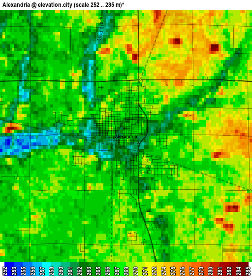
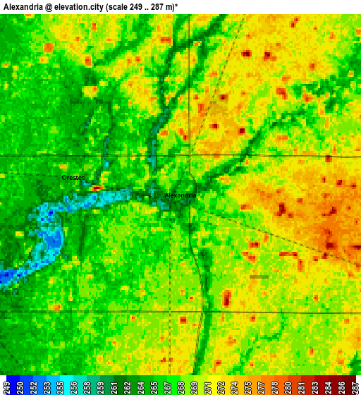
Below is the Elevation map of Alexandria, which displays elevation range with different colors. Scale of the first map is from 252 to 285 m (827 to 935 ft) with average elevation of 267.7 meters (=878 ft) [note 1]
These maps also provides idea of topography and contour of this city, they are displayed at different zoom levels. More info about maps, scale and edge coordinates you can find below images.
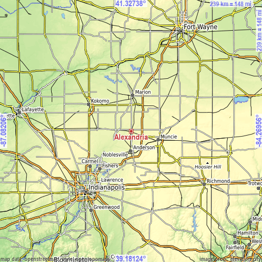
| \ | Map #1 | Map #2 | Topo.Map |
| Scale [m] | 252..285 m | 249..287 m | × |
| Scale [ft] | 827..935 ft | 817..942 ft | × |
| Average | 267.7 m = 878 ft | 268.4 m = 881 ft | × |
| Width | 7.46 km = 4.6 mi | 14.91 km = 9.3 mi | 238.6 km = 148.3 mi |
| Height | 7.46 km = 4.6 mi | 14.91 km = 9.3 mi | 238.6 km = 148.3 mi |
| ↑Max Latitude | 40.296346° | 40.329855° | 41.32738° |
| Latitude at center | 40.26282° | 40.26282° | 40.26282° |
| ↓Min Latitude | 40.229278° | 40.195718° | 39.18124° |
| ← Min Longitude | -85.719755° | -85.763701° | -87.08206° |
| Longitude center | -85.67581° | -85.67581° | -85.67581° |
| →Max Longitude | -85.631865° | -85.587919° | -84.26956° |
Nearby cities:
Cities around Alexandria sort by population:
• Muncie elevation 292 m
25.8 km,  107°
107°
• Anderson 275 m
17.5 km,  181°
181°
• Yorktown 282 m
18.3 km,  122°
122°
• Elwood 264 m
14.2 km,  276°
276°
• Gas City 261 m
25.5 km,  12°
12°
• Fairmount 265 m
17.1 km, 7°
• Chesterfield 276 m
18 km,  158°
158°
• Middletown 299 m
25.7 km,  152°
152°
• Edgewood 268 m
18.4 km,  195°
195°
• Frankton 253 m
9.8 km,  243°
243°
• Jonesboro 262 m
24.5 km, 9°
• Daleville 275 m
18.7 km, 147°
Multilingual:
 En español:
Alexandria elevación 266 m.
 En France:
Alexandria élévation 266 m.
 Auf Deutsch:
Alexandria höhe über dem Meeresspiegel ist 266 m.

Sources and notes:
- [note 1] Map square and city borders are not equal. Map elevation data is calculated only from area inside that square.
- [src 1] Elevation data from geonames database provided with same terms of usage.
- [src 2] The elevation map of Alexandria is generated using elevation data from NASA's 3 arcsec (90m) resolution SRTM data.
- [src 3] Base (background) map © OpenStreetMap contributors tiles are generated by Geofabrik and OpenTopoMap.
Copyright & License:
This Alexandria Elevation Map is licensed under CC BY-SA. You may reuse any part from this page, if you give a proper credit by linking to this URL:
 More info on terms of use page.