Markle elevation
Markle (Indiana, Huntington County), United States elevation is 237 meters and Markle elevation in feet is 778 ft above sea level [src 1]. Markle is a populated place (feature code) with elevation that is 42 meters (138 ft) smaller than average city elevation in United States.
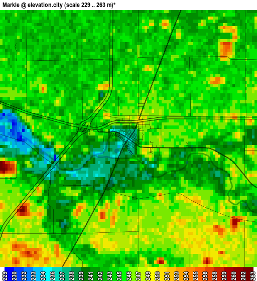
Below is the Elevation map of Markle, which displays elevation range with different colors. Scale of the first map is from 229 to 263 m (751 to 863 ft) with average elevation of 244.6 meters (=802 ft) [note 1]
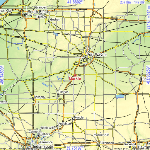
These maps also provides idea of topography and contour of this city, they are displayed at different zoom levels. More info about maps, scale and edge coordinates you can find below images.
| \ | Map #1 | Topo.Map |
| Scale [m] | 229..263 m | × |
| Scale [ft] | 751..863 ft | × |
| Average | 244.6 m = 802 ft | × |
| Width | 7.39 km = 4.6 mi | 236.6 km = 147 mi |
| Height | 7.39 km = 4.6 mi | 236.6 km = 147 mi |
| ↑Max Latitude | 40.857866° | 41.8802° |
| Latitude at center | 40.82462° | 40.82462° |
| ↓Min Latitude | 40.791358° | 39.75197° |
| ← Min Longitude | -85.382785° | -86.74509° |
| Longitude center | -85.33884° | -85.33884° |
| →Max Longitude | -85.294895° | -83.93259° |
Nearby cities:
Cities around Markle sort by population:
• Fort Wayne elevation 250 m
38.3 km,  27°
27°
• Huntington 230 m
14.8 km,  295°
295°
• New Haven 234 m
38.6 km,  44°
44°
• Bluffton 250 m
17 km,  124°
124°
• Decatur 245 m
34.5 km,  88°
88°
• Berne 257 m
37.5 km, 119°
• Ossian 257 m
15.8 km,  66°
66°
• South Whitley 246 m
37.8 km,  319°
319°
• Montpelier 267 m
30.5 km,  170°
170°
• Roanoke 233 m
15.6 km,  349°
349°
• Warren 254 m
17.4 km,  205°
205°
• Andrews 223 m
22.5 km,  280°
280°
Multilingual:
 En español:
Markle elevación 237 m.
 En France:
Markle élévation 237 m.


Sources and notes:
- [note 1] Map square and city borders are not equal. Map elevation data is calculated only from area inside that square.
- [src 1] Elevation data from geonames database provided with same terms of usage.
- [src 2] The elevation map of Markle is generated using elevation data from NASA's 3 arcsec (90m) resolution SRTM data.
- [src 3] Base (background) map © OpenStreetMap contributors tiles are generated by Geofabrik and OpenTopoMap.
Copyright & License:
This Markle Elevation Map is licensed under CC BY-SA. You may reuse any part from this page, if you give a proper credit by linking to this URL:
 More info on terms of use page.