Andrews elevation
Andrews (Indiana, Huntington County), United States elevation is 223 meters and Andrews elevation in feet is 732 ft above sea level [src 1]. Andrews is a populated place (feature code) with elevation that is 56 meters (184 ft) smaller than average city elevation in United States.
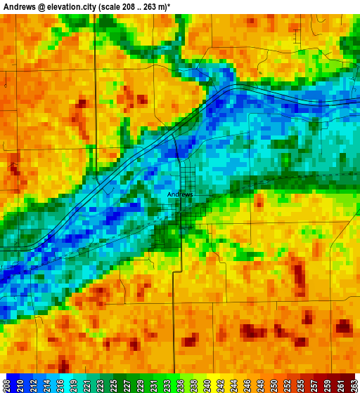
Below is the Elevation map of Andrews, which displays elevation range with different colors. Scale of the first map is from 208 to 263 m (682 to 863 ft) with average elevation of 236 meters (=774 ft) [note 1]
These maps also provides idea of topography and contour of this city, they are displayed at different zoom levels. More info about maps, scale and edge coordinates you can find below images.
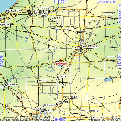
| \ | Map #1 | Topo.Map |
| Scale [m] | 208..263 m | × |
| Scale [ft] | 682..863 ft | × |
| Average | 236 m = 774 ft | × |
| Width | 7.39 km = 4.6 mi | 236.5 km = 147 mi |
| Height | 7.39 km = 4.6 mi | 236.5 km = 147 mi |
| ↑Max Latitude | 40.895767° | 41.91751° |
| Latitude at center | 40.86254° | 40.86254° |
| ↓Min Latitude | 40.829297° | 39.7905° |
| ← Min Longitude | -85.645595° | -87.0079° |
| Longitude center | -85.60165° | -85.60165° |
| →Max Longitude | -85.557705° | -84.1954° |
Nearby cities:
Cities around Andrews sort by population:
• Marion elevation 246 m
34.2 km,  188°
188°
• Huntington 230 m
9.1 km,  75°
75°
• Wabash 216 m
19.8 km,  248°
248°
• Columbia City 263 m
34.1 km,  16°
16°
• Mount Vernon 252 m
28.5 km,  221°
221°
• North Manchester 240 m
20.8 km,  317°
317°
• Ossian 257 m
36.7 km,  86°
86°
• South Whitley 246 m
24.8 km,  354°
354°
• Roanoke 233 m
22.2 km,  59°
59°
• Warren 254 m
24.8 km,  143°
143°
• Sweetser 262 m
35.3 km,  203°
203°
• Markle 237 m
22.5 km,  100°
100°
Multilingual:
 En español:
Andrews elevación 223 m.
 En France:
Andrews élévation 223 m.


Sources and notes:
- [note 1] Map square and city borders are not equal. Map elevation data is calculated only from area inside that square.
- [src 1] Elevation data from geonames database provided with same terms of usage.
- [src 2] The elevation map of Andrews is generated using elevation data from NASA's 3 arcsec (90m) resolution SRTM data.
- [src 3] Base (background) map © OpenStreetMap contributors tiles are generated by Geofabrik and OpenTopoMap.
Copyright & License:
This Andrews Elevation Map is licensed under CC BY-SA. You may reuse any part from this page, if you give a proper credit by linking to this URL:
 More info on terms of use page.