Lake Dalecarlia elevation
Lake Dalecarlia (Indiana, Lake County), United States elevation is 224 meters and Lake Dalecarlia elevation in feet is 735 ft above sea level [src 1]. Lake Dalecarlia is a populated place (feature code) with elevation that is 55 meters (180 ft) smaller than average city elevation in United States.
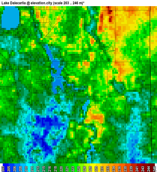
Below is the Elevation map of Lake Dalecarlia, which displays elevation range with different colors. Scale of the first map is from 203 to 246 m (666 to 807 ft) with average elevation of 219.2 meters (=719 ft) [note 1]
These maps also provides idea of topography and contour of this city, they are displayed at different zoom levels. More info about maps, scale and edge coordinates you can find below images.
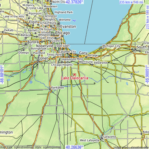
| \ | Map #1 | Topo.Map |
| Scale [m] | 203..246 m | × |
| Scale [ft] | 666..807 ft | × |
| Average | 219.2 m = 719 ft | × |
| Width | 7.34 km = 4.6 mi | 234.8 km = 145.9 mi |
| Height | 7.34 km = 4.6 mi | 234.8 km = 145.9 mi |
| ↑Max Latitude | 41.363861° | 42.37826° |
| Latitude at center | 41.33087° | 41.33087° |
| ↓Min Latitude | 41.297863° | 40.26636° |
| ← Min Longitude | -87.438705° | -88.80101° |
| Longitude center | -87.39476° | -87.39476° |
| →Max Longitude | -87.350815° | -85.98851° |
Nearby cities:
Cities around Lake Dalecarlia sort by population:
• Merrillville elevation 203 m
17.7 km,  17°
17°
• Crown Point 229 m
9.9 km,  14°
14°
• Schererville 207 m
17.2 km,  343°
343°
• Dyer 197 m
21 km,  329°
329°
• Saint John 224 m
14.7 km, 334°
• Cedar Lake 224 m
5.4 km,  314°
314°
• Lowell 206 m
4.9 km,  206°
206°
• Lakes of the Four Seasons 237 m
17.5 km,  59°
59°
• Winfield 217 m
13 km,  50°
50°
• Beecher 227 m
19 km,  273°
273°
• Hebron 216 m
16.3 km,  94°
94°
• Willowbrook 223 m
18.4 km,  320°
320°
Multilingual:
 En español:
Lake Dalecarlia elevación 224 m.
 En France:
Lake Dalecarlia élévation 224 m.
 Auf Deutsch:
Lake Dalecarlia höhe über dem Meeresspiegel ist 224 m.

Sources and notes:
- [note 1] Map square and city borders are not equal. Map elevation data is calculated only from area inside that square.
- [src 1] Elevation data from geonames database provided with same terms of usage.
- [src 2] The elevation map of Lake Dalecarlia is generated using elevation data from NASA's 3 arcsec (90m) resolution SRTM data.
- [src 3] Base (background) map © OpenStreetMap contributors tiles are generated by Geofabrik and OpenTopoMap.
Copyright & License:
This Lake Dalecarlia Elevation Map is licensed under CC BY-SA. You may reuse any part from this page, if you give a proper credit by linking to this URL:
 More info on terms of use page.