Kingsford Heights elevation
Kingsford Heights (Indiana, LaPorte County), United States elevation is 222 meters and Kingsford Heights elevation in feet is 728 ft above sea level [src 1]. Kingsford Heights is a populated place (feature code) with elevation that is 57 meters (187 ft) smaller than average city elevation in United States.
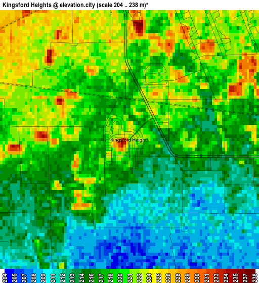
Below is the Elevation map of Kingsford Heights, which displays elevation range with different colors. Scale of the first map is from 204 to 238 m (669 to 781 ft) with average elevation of 217.4 meters (=713 ft) [note 1]
These maps also provides idea of topography and contour of this city, they are displayed at different zoom levels. More info about maps, scale and edge coordinates you can find below images.
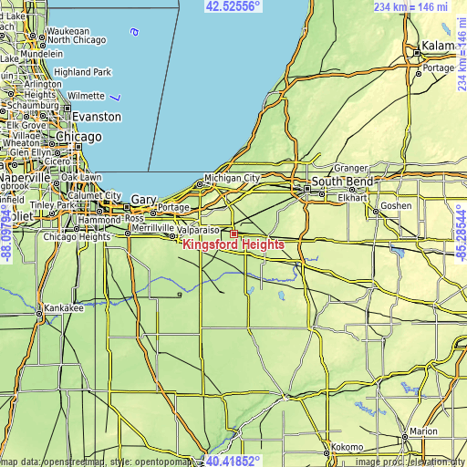
| \ | Map #1 | Topo.Map |
| Scale [m] | 204..238 m | × |
| Scale [ft] | 669..781 ft | × |
| Average | 217.4 m = 713 ft | × |
| Width | 7.32 km = 4.5 mi | 234.3 km = 145.6 mi |
| Height | 7.32 km = 4.5 mi | 234.3 km = 145.6 mi |
| ↑Max Latitude | 41.513515° | 42.52556° |
| Latitude at center | 41.4806° | 41.4806° |
| ↓Min Latitude | 41.447669° | 40.41852° |
| ← Min Longitude | -86.735635° | -88.09794° |
| Longitude center | -86.69169° | -86.69169° |
| →Max Longitude | -86.647745° | -85.28544° |
Nearby cities:
Cities around Kingsford Heights sort by population:
• LaPorte elevation 252 m
14.7 km,  349°
349°
• La Porte 249 m
14.3 km, 352°
• Westville 244 m
18.7 km,  291°
291°
• Knox 219 m
21.3 km,  164°
164°
• Walkerton 222 m
17.4 km,  95°
95°
• Trail Creek 200 m
27.9 km,  330°
330°
• North Liberty 224 m
22.8 km,  74°
74°
• New Carlisle 246 m
28.7 km,  31°
31°
• Koontz Lake 229 m
18.5 km,  112°
112°
• Hudson Lake 246 m
28.7 km, 27°
• Wanatah 226 m
18.1 km,  252°
252°
• Fish Lake 219 m
15.1 km,  50°
50°
Multilingual:
 En español:
Kingsford Heights elevación 222 m.
 En France:
Kingsford Heights élévation 222 m.
 Auf Deutsch:
Kingsford Heights höhe über dem Meeresspiegel ist 222 m.

Sources and notes:
- [note 1] Map square and city borders are not equal. Map elevation data is calculated only from area inside that square.
- [src 1] Elevation data from geonames database provided with same terms of usage.
- [src 2] The elevation map of Kingsford Heights is generated using elevation data from NASA's 3 arcsec (90m) resolution SRTM data.
- [src 3] Base (background) map © OpenStreetMap contributors tiles are generated by Geofabrik and OpenTopoMap.
Copyright & License:
This Kingsford Heights Elevation Map is licensed under CC BY-SA. You may reuse any part from this page, if you give a proper credit by linking to this URL:
 More info on terms of use page.