Georgetown elevation
Georgetown (Indiana, Cass County), United States elevation is 181 meters and Georgetown elevation in feet is 594 ft above sea level [src 1]. Georgetown is a populated place (feature code) with elevation that is 98 meters (322 ft) smaller than average city elevation in United States.
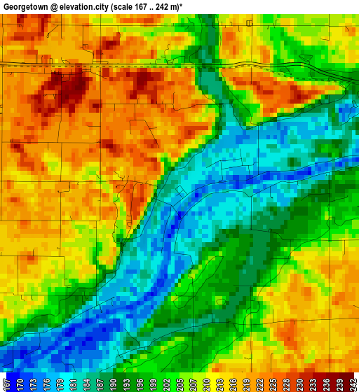
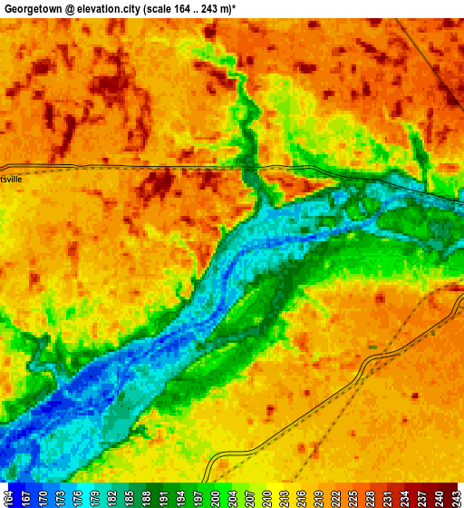
Below is the Elevation map of Georgetown, which displays elevation range with different colors. Scale of the first map is from 167 to 242 m (548 to 794 ft) with average elevation of 203.9 meters (=669 ft) [note 1]
These maps also provides idea of topography and contour of this city, they are displayed at different zoom levels. More info about maps, scale and edge coordinates you can find below images.
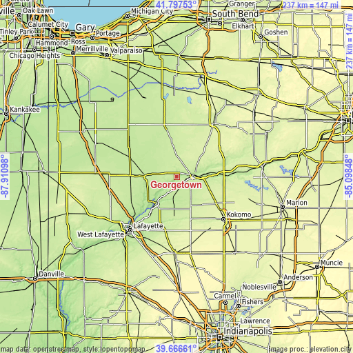
| \ | Map #1 | Map #2 | Topo.Map |
| Scale [m] | 167..242 m | 164..243 m | × |
| Scale [ft] | 548..794 ft | 538..797 ft | × |
| Average | 203.9 m = 669 ft | 210.2 m = 690 ft | × |
| Width | 7.4 km = 4.6 mi | 14.81 km = 9.2 mi | 236.9 km = 147.2 mi |
| Height | 7.4 km = 4.6 mi | 14.81 km = 9.2 mi | 236.9 km = 147.2 mi |
| ↑Max Latitude | 40.773888° | 40.807159° | 41.79753° |
| Latitude at center | 40.7406° | 40.7406° | 40.7406° |
| ↓Min Latitude | 40.707296° | 40.673974° | 39.66661° |
| ← Min Longitude | -86.548675° | -86.592621° | -87.91098° |
| Longitude center | -86.50473° | -86.50473° | -86.50473° |
| →Max Longitude | -86.460785° | -86.416839° | -85.09848° |
Nearby cities:
Cities around Georgetown sort by population:
• Logansport elevation 196 m
12.6 km,  82°
82°
• Peru 203 m
36.7 km,  87°
87°
• Grissom Air Force Base 243 m
31.5 km,  107°
107°
• Monticello 206 m
21.9 km,  271°
271°
• Delphi 176 m
22.3 km,  220°
220°
• Dunkirk 187 m
9.5 km, 79°
• Winamac 217 m
35.5 km,  346°
346°
• Flora 216 m
21.6 km,  184°
184°
• Monon 209 m
34.5 km,  294°
294°
• Brookston 209 m
34.2 km,  243°
243°
• Galveston 246 m
32 km,  124°
124°
• Walton 237 m
23.9 km, 111°
Multilingual:
 En español:
Georgetown elevación 181 m.
 En France:
Georgetown élévation 181 m.
 Auf Deutsch:
Georgetown höhe über dem Meeresspiegel ist 181 m.

Sources and notes:
- [note 1] Map square and city borders are not equal. Map elevation data is calculated only from area inside that square.
- [src 1] Elevation data from geonames database provided with same terms of usage.
- [src 2] The elevation map of Georgetown is generated using elevation data from NASA's 3 arcsec (90m) resolution SRTM data.
- [src 3] Base (background) map © OpenStreetMap contributors tiles are generated by Geofabrik and OpenTopoMap.
Copyright & License:
This Georgetown Elevation Map is licensed under CC BY-SA. You may reuse any part from this page, if you give a proper credit by linking to this URL:
 More info on terms of use page.