DeMotte elevation
DeMotte (Indiana, Jasper County), United States elevation is 206 meters and DeMotte elevation in feet is 676 ft above sea level [src 1]. DeMotte is a populated place (feature code) with elevation that is 73 meters (240 ft) smaller than average city elevation in United States.
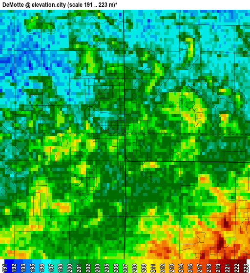
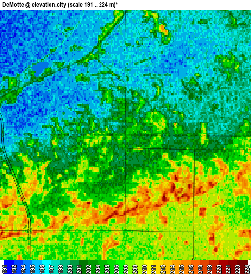
Below is the Elevation map of DeMotte, which displays elevation range with different colors. Scale of the first map is from 191 to 223 m (627 to 732 ft) with average elevation of 202.4 meters (=664 ft) [note 1]
These maps also provides idea of topography and contour of this city, they are displayed at different zoom levels. More info about maps, scale and edge coordinates you can find below images.
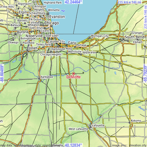
| \ | Map #1 | Map #2 | Topo.Map |
| Scale [m] | 191..223 m | 191..224 m | × |
| Scale [ft] | 627..732 ft | 627..735 ft | × |
| Average | 202.4 m = 664 ft | 202.9 m = 666 ft | × |
| Width | 7.35 km = 4.6 mi | 14.71 km = 9.1 mi | 235.3 km = 146.2 mi |
| Height | 7.35 km = 4.6 mi | 14.71 km = 9.1 mi | 235.3 km = 146.2 mi |
| ↑Max Latitude | 41.228099° | 41.261142° | 42.24464° |
| Latitude at center | 41.19504° | 41.19504° | 41.19504° |
| ↓Min Latitude | 41.161964° | 41.128871° | 40.12834° |
| ← Min Longitude | -87.242585° | -87.286531° | -88.60489° |
| Longitude center | -87.19864° | -87.19864° | -87.19864° |
| →Max Longitude | -87.154695° | -87.110749° | -85.79239° |
Nearby cities:
Cities around DeMotte sort by population:
• Crown Point elevation 229 m
28.3 km,  330°
330°
• Cedar Lake 224 m
27.7 km,  312°
312°
• Lowell 206 m
21.4 km,  300°
300°
• Lakes of the Four Seasons 237 m
24 km,  357°
357°
• Rensselaer 204 m
29 km,  172°
172°
• Winfield 217 m
24.2 km,  344°
344°
• Roselawn 209 m
11.4 km,  238°
238°
• Hebron 216 m
13.7 km, 359°
• Shorewood Forest 220 m
30.1 km,  8°
8°
• Kouts 209 m
19.8 km,  46°
46°
• Aberdeen 226 m
28.1 km,  15°
15°
• Lake Dalecarlia 224 m
22.3 km, 312°
Multilingual:
 En español:
DeMotte elevación 206 m.
 En France:
DeMotte élévation 206 m.


Sources and notes:
- [note 1] Map square and city borders are not equal. Map elevation data is calculated only from area inside that square.
- [src 1] Elevation data from geonames database provided with same terms of usage.
- [src 2] The elevation map of DeMotte is generated using elevation data from NASA's 3 arcsec (90m) resolution SRTM data.
- [src 3] Base (background) map © OpenStreetMap contributors tiles are generated by Geofabrik and OpenTopoMap.
Copyright & License:
This DeMotte Elevation Map is licensed under CC BY-SA. You may reuse any part from this page, if you give a proper credit by linking to this URL:
 More info on terms of use page.